You are here: Home > Network List > IU - Global Seismograph Network (GSN - IRIS/USGS) Stations List
> Station RSSD Black Hills, South Dakota, USA > Earthquake Result Viewer
RSSD Black Hills, South Dakota, USA - Earthquake Result Viewer
| Earthquake location: |
Near Coast Of Ecuador |
| Earthquake latitude/longitude: |
0.6/-80.3 |
| Earthquake time(UTC): |
2016/04/20 (111) 08:33:48 GMT |
| Earthquake Depth: |
16 km |
| Earthquake Magnitude: |
6.1 MO |
| Earthquake Catalog/Contributor: |
NEIC PDE/NEIC ALERT |
|
| Network: |
IU Global Seismograph Network (GSN - IRIS/USGS) |
| Station: |
RSSD Black Hills, South Dakota, USA |
| Lat/Lon: |
44.12 N/104.04 W |
| Elevation: |
2090 m |
|
| Distance: |
48.2 deg |
| Az: |
337.084 deg |
| Baz: |
147.273 deg |
| Ray Param: |
0.06948771 |
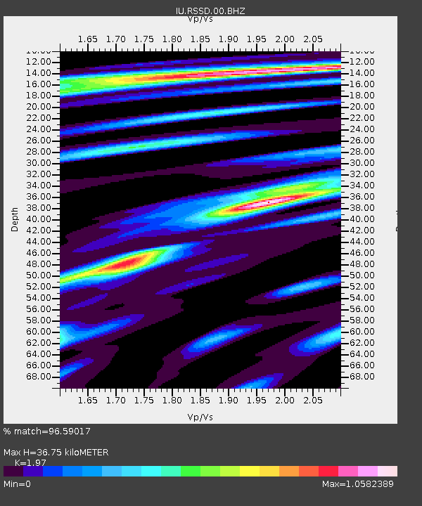
| Estimated Moho Depth: |
36.75 km |
| Estimated Crust Vp/Vs: |
1.97 |
| Assumed Crust Vp: |
6.242 km/s |
| Estimated Crust Vs: |
3.169 km/s |
| Estimated Crust Poisson's Ratio: |
0.33 |
|
| Radial Match: |
96.59017 % |
| Radial Bump: |
317 |
| Transverse Match: |
86.01768 % |
| Transverse Bump: |
400 |
| SOD ConfigId: |
1475611 |
| Insert Time: |
2016-05-04 08:43:26.713 +0000 |
| GWidth: |
2.5 |
| Max Bumps: |
400 |
| Tol: |
0.001 |
|
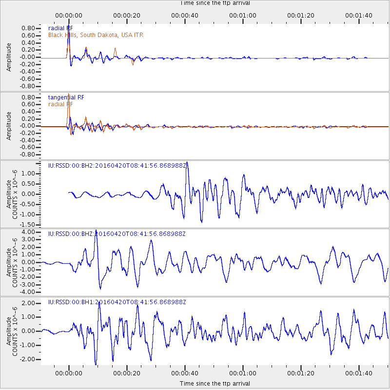
Signal To Noise
| Channel | StoN | STA | LTA |
| IU:RSSD:00:BHZ:20160420T08:41:56.868988Z | 7.2875166 | 5.5905286E-7 | 7.6713775E-8 |
| IU:RSSD:00:BH1:20160420T08:41:56.868988Z | 2.4830332 | 2.8382004E-7 | 1.1430377E-7 |
| IU:RSSD:00:BH2:20160420T08:41:56.868988Z | 2.8094141 | 2.485401E-7 | 8.846687E-8 |
| Arrivals |
| Ps | 6.0 SECOND |
| PpPs | 17 SECOND |
| PsPs/PpSs | 23 SECOND |


