You are here: Home > Network List > TA - USArray Transportable Network (new EarthScope stations) Stations List
> Station L15K Ungalak Mountain, AK, USA > Earthquake Result Viewer
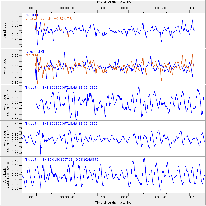
L15K Ungalak Mountain, AK, USA - Earthquake Result Viewer
*The percent match for this event was below the threshold and hence no stack was calculated.
| Earthquake location: |
Vanuatu Islands |
| Earthquake latitude/longitude: |
-19.0/169.5 |
| Earthquake time(UTC): |
2018/02/06 (037) 18:37:59 GMT |
| Earthquake Depth: |
246 km |
| Earthquake Magnitude: |
5.6 Mww |
| Earthquake Catalog/Contributor: |
NEIC PDE/us |
|
| Network: |
TA USArray Transportable Network (new EarthScope stations) |
| Station: |
L15K Ungalak Mountain, AK, USA |
| Lat/Lon: |
61.68 N/161.49 W |
| Elevation: |
219 m |
|
| Distance: |
83.7 deg |
| Az: |
13.472 deg |
| Baz: |
207.536 deg |
| Ray Param: |
$rayparam |
*The percent match for this event was below the threshold and hence was not used in the summary stack. |
|
| Radial Match: |
53.74715 % |
| Radial Bump: |
400 |
| Transverse Match: |
54.06228 % |
| Transverse Bump: |
400 |
| SOD ConfigId: |
13570011 |
| Insert Time: |
2019-04-29 17:49:17.661 +0000 |
| GWidth: |
2.5 |
| Max Bumps: |
400 |
| Tol: |
0.001 |
|
Signal To Noise
| Channel | StoN | STA | LTA |
| TA:L15K: :BHZ:20180206T18:49:28.924985Z | 2.296519 | 5.3686574E-7 | 2.3377369E-7 |
| TA:L15K: :BHN:20180206T18:49:28.924985Z | 1.172147 | 2.9465704E-7 | 2.5138232E-7 |
| TA:L15K: :BHE:20180206T18:49:28.924985Z | 0.5184025 | 1.2365189E-7 | 2.3852485E-7 |
| Arrivals |
| Ps | |
| PpPs | |
| PsPs/PpSs | |


