You are here: Home > Network List > IW - Intermountain West Stations List
> Station PHWY Pilot Hill, Wyoming, USA > Earthquake Result Viewer
PHWY Pilot Hill, Wyoming, USA - Earthquake Result Viewer
| Earthquake location: |
Near Coast Of Ecuador |
| Earthquake latitude/longitude: |
0.6/-80.3 |
| Earthquake time(UTC): |
2016/04/20 (111) 08:33:48 GMT |
| Earthquake Depth: |
16 km |
| Earthquake Magnitude: |
6.1 MO |
| Earthquake Catalog/Contributor: |
NEIC PDE/NEIC ALERT |
|
| Network: |
IW Intermountain West |
| Station: |
PHWY Pilot Hill, Wyoming, USA |
| Lat/Lon: |
41.30 N/105.46 W |
| Elevation: |
2645 m |
|
| Distance: |
46.5 deg |
| Az: |
333.746 deg |
| Baz: |
144.05 deg |
| Ray Param: |
0.070604056 |
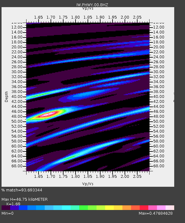
| Estimated Moho Depth: |
46.75 km |
| Estimated Crust Vp/Vs: |
1.69 |
| Assumed Crust Vp: |
6.306 km/s |
| Estimated Crust Vs: |
3.731 km/s |
| Estimated Crust Poisson's Ratio: |
0.23 |
|
| Radial Match: |
93.693344 % |
| Radial Bump: |
264 |
| Transverse Match: |
81.78942 % |
| Transverse Bump: |
400 |
| SOD ConfigId: |
1475611 |
| Insert Time: |
2016-05-04 08:44:52.324 +0000 |
| GWidth: |
2.5 |
| Max Bumps: |
400 |
| Tol: |
0.001 |
|

Signal To Noise
| Channel | StoN | STA | LTA |
| IW:PHWY:00:BHZ:20160420T08:41:43.394012Z | 7.85511 | 5.2322804E-7 | 6.660989E-8 |
| IW:PHWY:00:BH1:20160420T08:41:43.394012Z | 3.276374 | 2.394786E-7 | 7.3092565E-8 |
| IW:PHWY:00:BH2:20160420T08:41:43.394012Z | 3.4075205 | 2.571806E-7 | 7.547441E-8 |
| Arrivals |
| Ps | 5.4 SECOND |
| PpPs | 19 SECOND |
| PsPs/PpSs | 24 SECOND |


