You are here: Home > Network List > TA - USArray Transportable Network (new EarthScope stations) Stations List
> Station C13A Hot Springs, MT, USA > Earthquake Result Viewer
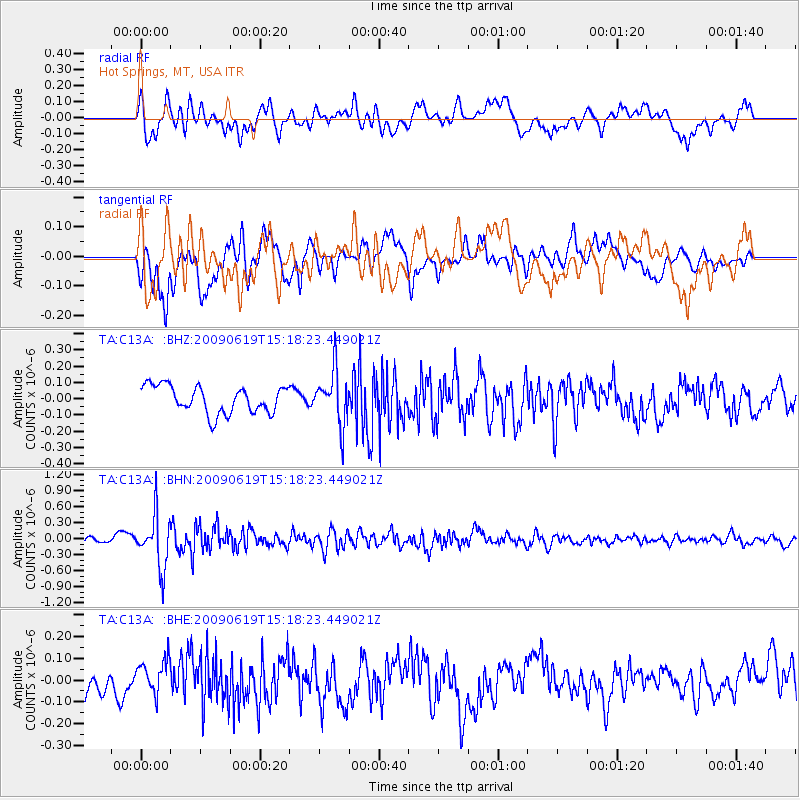
C13A Hot Springs, MT, USA - Earthquake Result Viewer
*The percent match for this event was below the threshold and hence no stack was calculated.
| Earthquake location: |
Mariana Islands |
| Earthquake latitude/longitude: |
14.1/145.2 |
| Earthquake time(UTC): |
2009/06/19 (170) 15:06:24 GMT |
| Earthquake Depth: |
114 km |
| Earthquake Magnitude: |
5.5 MB, 5.5 MW |
| Earthquake Catalog/Contributor: |
WHDF/NEIC |
|
| Network: |
TA USArray Transportable Network (new EarthScope stations) |
| Station: |
C13A Hot Springs, MT, USA |
| Lat/Lon: |
47.68 N/114.57 W |
| Elevation: |
976 m |
|
| Distance: |
86.5 deg |
| Az: |
41.779 deg |
| Baz: |
286.917 deg |
| Ray Param: |
$rayparam |
*The percent match for this event was below the threshold and hence was not used in the summary stack. |
|
| Radial Match: |
60.78345 % |
| Radial Bump: |
400 |
| Transverse Match: |
59.23067 % |
| Transverse Bump: |
400 |
| SOD ConfigId: |
2648 |
| Insert Time: |
2010-03-06 08:42:20.504 +0000 |
| GWidth: |
2.5 |
| Max Bumps: |
400 |
| Tol: |
0.001 |
|
Signal To Noise
| Channel | StoN | STA | LTA |
| TA:C13A: :BHN:20090619T15:18:23.449021Z | 5.926622 | 4.8436664E-7 | 8.172727E-8 |
| TA:C13A: :BHE:20090619T15:18:23.449021Z | 1.0493513 | 8.551322E-8 | 8.14915E-8 |
| TA:C13A: :BHZ:20090619T15:18:23.449021Z | 1.9215416 | 1.6122833E-7 | 8.390572E-8 |
| Arrivals |
| Ps | |
| PpPs | |
| PsPs/PpSs | |


