You are here: Home > Network List > TA - USArray Transportable Network (new EarthScope stations) Stations List
> Station C13A Hot Springs, MT, USA > Earthquake Result Viewer
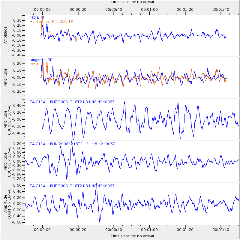
C13A Hot Springs, MT, USA - Earthquake Result Viewer
*The percent match for this event was below the threshold and hence no stack was calculated.
| Earthquake location: |
Near Coast Of Central Chile |
| Earthquake latitude/longitude: |
-32.5/-71.7 |
| Earthquake time(UTC): |
2008/12/18 (353) 21:19:28 GMT |
| Earthquake Depth: |
18 km |
| Earthquake Magnitude: |
5.8 MB, 6.0 MS, 6.2 MW, 6.1 MW |
| Earthquake Catalog/Contributor: |
WHDF/NEIC |
|
| Network: |
TA USArray Transportable Network (new EarthScope stations) |
| Station: |
C13A Hot Springs, MT, USA |
| Lat/Lon: |
47.68 N/114.57 W |
| Elevation: |
976 m |
|
| Distance: |
88.6 deg |
| Az: |
332.633 deg |
| Baz: |
144.893 deg |
| Ray Param: |
$rayparam |
*The percent match for this event was below the threshold and hence was not used in the summary stack. |
|
| Radial Match: |
50.43876 % |
| Radial Bump: |
400 |
| Transverse Match: |
64.71378 % |
| Transverse Bump: |
400 |
| SOD ConfigId: |
2658 |
| Insert Time: |
2010-03-06 08:42:21.358 +0000 |
| GWidth: |
2.5 |
| Max Bumps: |
400 |
| Tol: |
0.001 |
|
Signal To Noise
| Channel | StoN | STA | LTA |
| TA:C13A: :BHN:20081218T21:31:48.424006Z | 3.2570722 | 4.1080284E-7 | 1.2612641E-7 |
| TA:C13A: :BHE:20081218T21:31:48.424006Z | 1.2700319 | 1.9043574E-7 | 1.4994563E-7 |
| TA:C13A: :BHZ:20081218T21:31:48.424006Z | 0.6824406 | 1.7984439E-7 | 2.6353123E-7 |
| Arrivals |
| Ps | |
| PpPs | |
| PsPs/PpSs | |


