You are here: Home > Network List > TA - USArray Transportable Network (new EarthScope stations) Stations List
> Station C13A Hot Springs, MT, USA > Earthquake Result Viewer
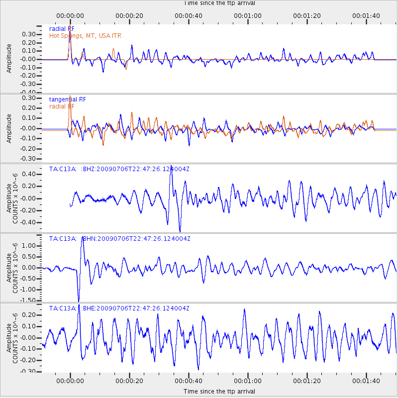
C13A Hot Springs, MT, USA - Earthquake Result Viewer
*The percent match for this event was below the threshold and hence no stack was calculated.
| Earthquake location: |
Southeast Of Ryukyu Islands |
| Earthquake latitude/longitude: |
24.9/128.0 |
| Earthquake time(UTC): |
2009/07/06 (187) 22:35:05 GMT |
| Earthquake Depth: |
10 km |
| Earthquake Magnitude: |
6.1 MB, 5.3 MS, 5.7 MW, 5.7 MW |
| Earthquake Catalog/Contributor: |
WHDF/NEIC |
|
| Network: |
TA USArray Transportable Network (new EarthScope stations) |
| Station: |
C13A Hot Springs, MT, USA |
| Lat/Lon: |
47.68 N/114.57 W |
| Elevation: |
976 m |
|
| Distance: |
88.5 deg |
| Az: |
36.88 deg |
| Baz: |
306.227 deg |
| Ray Param: |
$rayparam |
*The percent match for this event was below the threshold and hence was not used in the summary stack. |
|
| Radial Match: |
67.66893 % |
| Radial Bump: |
400 |
| Transverse Match: |
82.39756 % |
| Transverse Bump: |
400 |
| SOD ConfigId: |
2648 |
| Insert Time: |
2010-03-06 08:42:27.354 +0000 |
| GWidth: |
2.5 |
| Max Bumps: |
400 |
| Tol: |
0.001 |
|
Signal To Noise
| Channel | StoN | STA | LTA |
| TA:C13A: :BHN:20090706T22:47:26.124004Z | 12.812539 | 7.0905446E-7 | 5.5340667E-8 |
| TA:C13A: :BHE:20090706T22:47:26.124004Z | 2.5988822 | 1.2997181E-7 | 5.0010662E-8 |
| TA:C13A: :BHZ:20090706T22:47:26.124004Z | 3.4285774 | 2.403787E-7 | 7.011033E-8 |
| Arrivals |
| Ps | |
| PpPs | |
| PsPs/PpSs | |


