You are here: Home > Network List > NE - New England Seismic Network Stations List
> Station BCX Chestnut Hill, MA, USA > Earthquake Result Viewer
BCX Chestnut Hill, MA, USA - Earthquake Result Viewer
| Earthquake location: |
Near Coast Of Ecuador |
| Earthquake latitude/longitude: |
0.6/-80.3 |
| Earthquake time(UTC): |
2016/04/20 (111) 08:33:48 GMT |
| Earthquake Depth: |
16 km |
| Earthquake Magnitude: |
6.1 MO |
| Earthquake Catalog/Contributor: |
NEIC PDE/NEIC ALERT |
|
| Network: |
NE New England Seismic Network |
| Station: |
BCX Chestnut Hill, MA, USA |
| Lat/Lon: |
42.33 N/71.17 W |
| Elevation: |
60 m |
|
| Distance: |
42.3 deg |
| Az: |
10.016 deg |
| Baz: |
193.565 deg |
| Ray Param: |
0.07321706 |
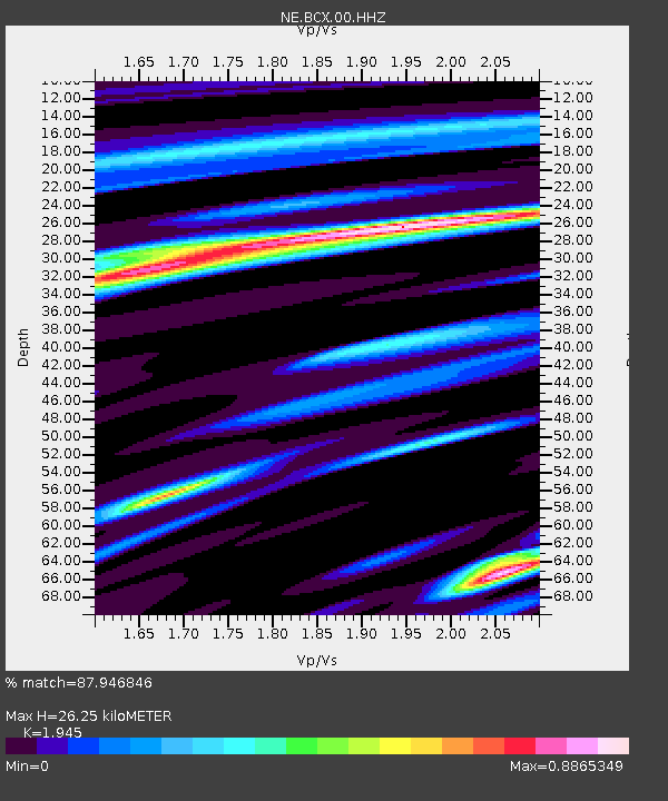
| Estimated Moho Depth: |
26.25 km |
| Estimated Crust Vp/Vs: |
1.95 |
| Assumed Crust Vp: |
6.419 km/s |
| Estimated Crust Vs: |
3.3 km/s |
| Estimated Crust Poisson's Ratio: |
0.32 |
|
| Radial Match: |
87.946846 % |
| Radial Bump: |
328 |
| Transverse Match: |
61.854534 % |
| Transverse Bump: |
400 |
| SOD ConfigId: |
1475611 |
| Insert Time: |
2016-05-04 08:46:27.198 +0000 |
| GWidth: |
2.5 |
| Max Bumps: |
400 |
| Tol: |
0.001 |
|

Signal To Noise
| Channel | StoN | STA | LTA |
| NE:BCX:00:HHZ:20160420T08:41:10.324005Z | 3.8568525 | 7.1953735E-7 | 1.8656077E-7 |
| NE:BCX:00:HH1:20160420T08:41:10.324005Z | 2.4866107 | 5.2772094E-7 | 2.1222499E-7 |
| NE:BCX:00:HH2:20160420T08:41:10.324005Z | 1.5740546 | 2.7126376E-7 | 1.723344E-7 |
| Arrivals |
| Ps | 4.1 SECOND |
| PpPs | 11 SECOND |
| PsPs/PpSs | 15 SECOND |


