You are here: Home > Network List > TA - USArray Transportable Network (new EarthScope stations) Stations List
> Station C13A Hot Springs, MT, USA > Earthquake Result Viewer
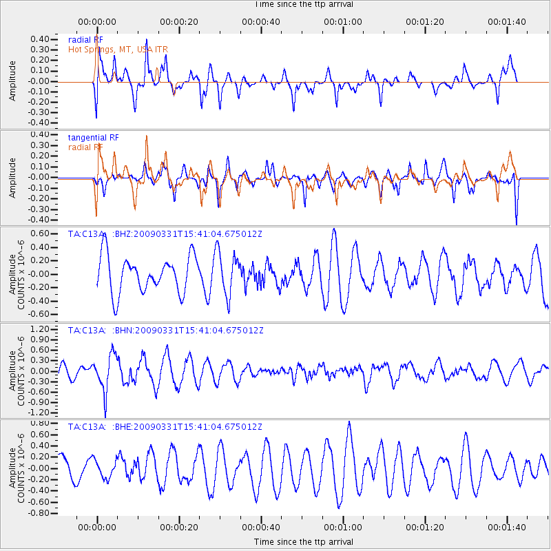
C13A Hot Springs, MT, USA - Earthquake Result Viewer
*The percent match for this event was below the threshold and hence no stack was calculated.
| Earthquake location: |
Mariana Islands |
| Earthquake latitude/longitude: |
18.3/145.7 |
| Earthquake time(UTC): |
2009/03/31 (090) 15:29:31 GMT |
| Earthquake Depth: |
188 km |
| Earthquake Magnitude: |
5.5 MW, 5.4 MB, 5.4 MW |
| Earthquake Catalog/Contributor: |
WHDF/NEIC |
|
| Network: |
TA USArray Transportable Network (new EarthScope stations) |
| Station: |
C13A Hot Springs, MT, USA |
| Lat/Lon: |
47.68 N/114.57 W |
| Elevation: |
976 m |
|
| Distance: |
83.0 deg |
| Az: |
42.15 deg |
| Baz: |
289.368 deg |
| Ray Param: |
$rayparam |
*The percent match for this event was below the threshold and hence was not used in the summary stack. |
|
| Radial Match: |
64.61775 % |
| Radial Bump: |
400 |
| Transverse Match: |
55.30038 % |
| Transverse Bump: |
400 |
| SOD ConfigId: |
2658 |
| Insert Time: |
2010-03-06 08:42:39.151 +0000 |
| GWidth: |
2.5 |
| Max Bumps: |
400 |
| Tol: |
0.001 |
|
Signal To Noise
| Channel | StoN | STA | LTA |
| TA:C13A: :BHN:20090331T15:41:04.675012Z | 1.8823268 | 5.247027E-7 | 2.787522E-7 |
| TA:C13A: :BHE:20090331T15:41:04.675012Z | 0.62618756 | 1.5217843E-7 | 2.4302372E-7 |
| TA:C13A: :BHZ:20090331T15:41:04.675012Z | 1.1844463 | 3.2041282E-7 | 2.7051698E-7 |
| Arrivals |
| Ps | |
| PpPs | |
| PsPs/PpSs | |


