You are here: Home > Network List > TA - USArray Transportable Network (new EarthScope stations) Stations List
> Station C13A Hot Springs, MT, USA > Earthquake Result Viewer
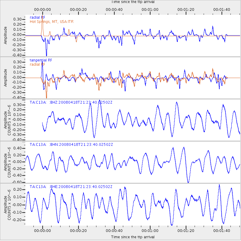
C13A Hot Springs, MT, USA - Earthquake Result Viewer
*The percent match for this event was below the threshold and hence no stack was calculated.
| Earthquake location: |
Kermadec Islands Region |
| Earthquake latitude/longitude: |
-27.5/-176.6 |
| Earthquake time(UTC): |
2008/04/18 (109) 21:10:56 GMT |
| Earthquake Depth: |
10 km |
| Earthquake Magnitude: |
5.6 MS, 5.4 MB, 5.8 MW, 5.8 MW |
| Earthquake Catalog/Contributor: |
WHDF/NEIC |
|
| Network: |
TA USArray Transportable Network (new EarthScope stations) |
| Station: |
C13A Hot Springs, MT, USA |
| Lat/Lon: |
47.68 N/114.57 W |
| Elevation: |
976 m |
|
| Distance: |
93.3 deg |
| Az: |
36.703 deg |
| Baz: |
231.761 deg |
| Ray Param: |
$rayparam |
*The percent match for this event was below the threshold and hence was not used in the summary stack. |
|
| Radial Match: |
50.488396 % |
| Radial Bump: |
362 |
| Transverse Match: |
58.325558 % |
| Transverse Bump: |
314 |
| SOD ConfigId: |
2504 |
| Insert Time: |
2010-03-06 08:42:44.673 +0000 |
| GWidth: |
2.5 |
| Max Bumps: |
400 |
| Tol: |
0.001 |
|
Signal To Noise
| Channel | StoN | STA | LTA |
| TA:C13A: :BHN:20080418T21:23:40.02502Z | 0.8498438 | 1.2120218E-7 | 1.4261701E-7 |
| TA:C13A: :BHE:20080418T21:23:40.02502Z | 1.2145909 | 1.00496386E-7 | 8.274093E-8 |
| TA:C13A: :BHZ:20080418T21:23:40.02502Z | 2.2841194 | 2.3785634E-7 | 1.0413481E-7 |
| Arrivals |
| Ps | |
| PpPs | |
| PsPs/PpSs | |


