You are here: Home > Network List > TA - USArray Transportable Network (new EarthScope stations) Stations List
> Station E20K Nigu River, AK, USA > Earthquake Result Viewer
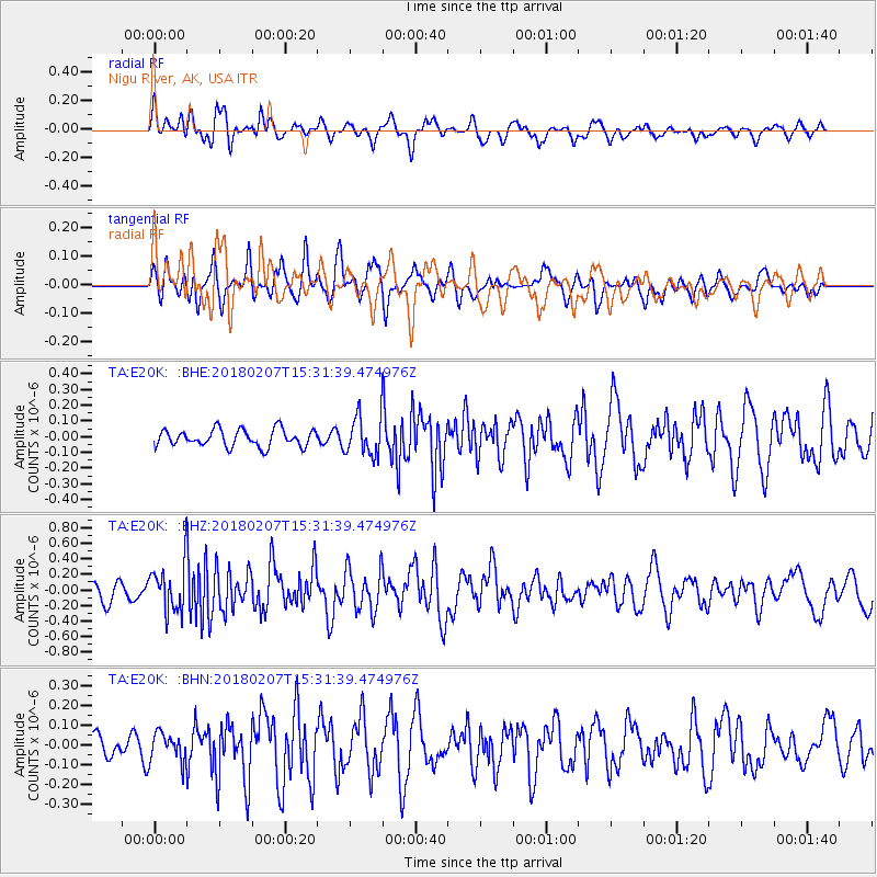
E20K Nigu River, AK, USA - Earthquake Result Viewer
*The percent match for this event was below the threshold and hence no stack was calculated.
| Earthquake location: |
Taiwan |
| Earthquake latitude/longitude: |
24.1/121.7 |
| Earthquake time(UTC): |
2018/02/07 (038) 15:21:31 GMT |
| Earthquake Depth: |
11 km |
| Earthquake Magnitude: |
5.7 Mww |
| Earthquake Catalog/Contributor: |
NEIC PDE/us |
|
| Network: |
TA USArray Transportable Network (new EarthScope stations) |
| Station: |
E20K Nigu River, AK, USA |
| Lat/Lon: |
68.26 N/156.19 W |
| Elevation: |
866 m |
|
| Distance: |
64.9 deg |
| Az: |
24.042 deg |
| Baz: |
272.172 deg |
| Ray Param: |
$rayparam |
*The percent match for this event was below the threshold and hence was not used in the summary stack. |
|
| Radial Match: |
66.9693 % |
| Radial Bump: |
400 |
| Transverse Match: |
56.087673 % |
| Transverse Bump: |
394 |
| SOD ConfigId: |
13570011 |
| Insert Time: |
2019-04-29 18:05:13.818 +0000 |
| GWidth: |
2.5 |
| Max Bumps: |
400 |
| Tol: |
0.001 |
|
Signal To Noise
| Channel | StoN | STA | LTA |
| TA:E20K: :BHZ:20180207T15:31:39.474976Z | 3.3545353 | 2.9548394E-7 | 8.808491E-8 |
| TA:E20K: :BHN:20180207T15:31:39.474976Z | 1.646741 | 7.0585656E-8 | 4.2863846E-8 |
| TA:E20K: :BHE:20180207T15:31:39.474976Z | 2.423851 | 1.31808E-7 | 5.437958E-8 |
| Arrivals |
| Ps | |
| PpPs | |
| PsPs/PpSs | |


