You are here: Home > Network List > TA - USArray Transportable Network (new EarthScope stations) Stations List
> Station R33M Jennings River, BC, CAN > Earthquake Result Viewer
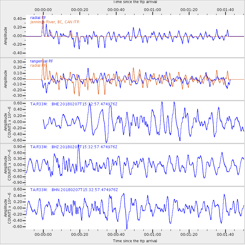
R33M Jennings River, BC, CAN - Earthquake Result Viewer
*The percent match for this event was below the threshold and hence no stack was calculated.
| Earthquake location: |
Taiwan |
| Earthquake latitude/longitude: |
24.1/121.7 |
| Earthquake time(UTC): |
2018/02/07 (038) 15:21:31 GMT |
| Earthquake Depth: |
11 km |
| Earthquake Magnitude: |
5.7 Mww |
| Earthquake Catalog/Contributor: |
NEIC PDE/us |
|
| Network: |
TA USArray Transportable Network (new EarthScope stations) |
| Station: |
R33M Jennings River, BC, CAN |
| Lat/Lon: |
59.39 N/130.97 W |
| Elevation: |
1437 m |
|
| Distance: |
77.9 deg |
| Az: |
29.977 deg |
| Baz: |
296.821 deg |
| Ray Param: |
$rayparam |
*The percent match for this event was below the threshold and hence was not used in the summary stack. |
|
| Radial Match: |
47.177433 % |
| Radial Bump: |
400 |
| Transverse Match: |
52.953594 % |
| Transverse Bump: |
400 |
| SOD ConfigId: |
13570011 |
| Insert Time: |
2019-04-29 18:05:48.154 +0000 |
| GWidth: |
2.5 |
| Max Bumps: |
400 |
| Tol: |
0.001 |
|
Signal To Noise
| Channel | StoN | STA | LTA |
| TA:R33M: :BHZ:20180207T15:32:57.474976Z | 1.1425953 | 2.5755887E-7 | 2.2541566E-7 |
| TA:R33M: :BHN:20180207T15:32:57.474976Z | 1.4292412 | 1.7399701E-7 | 1.2174084E-7 |
| TA:R33M: :BHE:20180207T15:32:57.474976Z | 2.3952835 | 3.316182E-7 | 1.3844634E-7 |
| Arrivals |
| Ps | |
| PpPs | |
| PsPs/PpSs | |


