You are here: Home > Network List > TA - USArray Transportable Network (new EarthScope stations) Stations List
> Station X17A Forest Lakes, AZ, USA > Earthquake Result Viewer
X17A Forest Lakes, AZ, USA - Earthquake Result Viewer
| Earthquake location: |
Chile-Bolivia Border Region |
| Earthquake latitude/longitude: |
-20.0/-69.0 |
| Earthquake time(UTC): |
2008/03/24 (084) 20:39:07 GMT |
| Earthquake Depth: |
120 km |
| Earthquake Magnitude: |
5.7 MB, 6.2 MW, 6.1 MW |
| Earthquake Catalog/Contributor: |
WHDF/NEIC |
|
| Network: |
TA USArray Transportable Network (new EarthScope stations) |
| Station: |
X17A Forest Lakes, AZ, USA |
| Lat/Lon: |
34.34 N/110.81 W |
| Elevation: |
2280 m |
|
| Distance: |
67.2 deg |
| Az: |
323.201 deg |
| Baz: |
137.111 deg |
| Ray Param: |
0.056823645 |
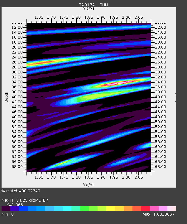
| Estimated Moho Depth: |
34.25 km |
| Estimated Crust Vp/Vs: |
1.97 |
| Assumed Crust Vp: |
6.207 km/s |
| Estimated Crust Vs: |
3.159 km/s |
| Estimated Crust Poisson's Ratio: |
0.33 |
|
| Radial Match: |
80.97749 % |
| Radial Bump: |
400 |
| Transverse Match: |
66.71435 % |
| Transverse Bump: |
400 |
| SOD ConfigId: |
2564 |
| Insert Time: |
2010-03-06 08:43:32.624 +0000 |
| GWidth: |
2.5 |
| Max Bumps: |
400 |
| Tol: |
0.001 |
|
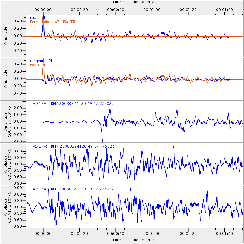
Signal To Noise
| Channel | StoN | STA | LTA |
| TA:X17A: :BHN:20080324T20:49:17.77502Z | 2.3882146 | 2.4868336E-7 | 1.04129406E-7 |
| TA:X17A: :BHE:20080324T20:49:17.77502Z | 2.3733628 | 3.287537E-7 | 1.385181E-7 |
| TA:X17A: :BHZ:20080324T20:49:17.77502Z | 10.613682 | 9.891063E-7 | 9.319163E-8 |
| Arrivals |
| Ps | 5.5 SECOND |
| PpPs | 16 SECOND |
| PsPs/PpSs | 21 SECOND |


