You are here: Home > Network List > CI - Caltech Regional Seismic Network Stations List
> Station IRM Iron Mountain Pumping Station, Eagle Mtn., CA, USA > Earthquake Result Viewer
IRM Iron Mountain Pumping Station, Eagle Mtn., CA, USA - Earthquake Result Viewer
| Earthquake location: |
Vanuatu Islands |
| Earthquake latitude/longitude: |
-14.3/167.3 |
| Earthquake time(UTC): |
2005/02/08 (039) 14:48:21 GMT |
| Earthquake Depth: |
206 km |
| Earthquake Magnitude: |
6.1 MB, 6.8 MW, 6.7 MW |
| Earthquake Catalog/Contributor: |
WHDF/NEIC |
|
| Network: |
CI Caltech Regional Seismic Network |
| Station: |
IRM Iron Mountain Pumping Station, Eagle Mtn., CA, USA |
| Lat/Lon: |
34.16 N/115.15 W |
| Elevation: |
567 m |
|
| Distance: |
87.9 deg |
| Az: |
54.136 deg |
| Baz: |
251.369 deg |
| Ray Param: |
0.042474624 |
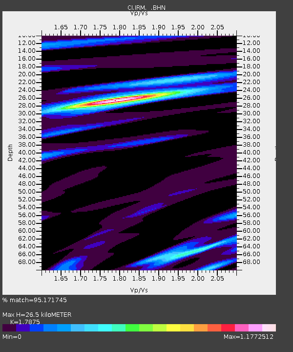
| Estimated Moho Depth: |
26.5 km |
| Estimated Crust Vp/Vs: |
1.79 |
| Assumed Crust Vp: |
6.276 km/s |
| Estimated Crust Vs: |
3.511 km/s |
| Estimated Crust Poisson's Ratio: |
0.27 |
|
| Radial Match: |
95.171745 % |
| Radial Bump: |
261 |
| Transverse Match: |
83.57098 % |
| Transverse Bump: |
400 |
| SOD ConfigId: |
5233 |
| Insert Time: |
2010-02-26 01:47:44.708 +0000 |
| GWidth: |
2.5 |
| Max Bumps: |
400 |
| Tol: |
0.001 |
|
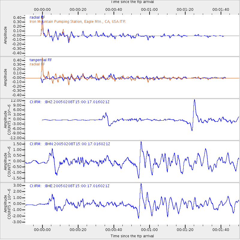
Signal To Noise
| Channel | StoN | STA | LTA |
| CI:IRM: :BHN:20050208T15:00:17.016021Z | 4.463717 | 3.1110383E-7 | 6.969614E-8 |
| CI:IRM: :BHE:20050208T15:00:17.016021Z | 4.429749 | 3.678623E-7 | 8.3043595E-8 |
| CI:IRM: :BHZ:20050208T15:00:17.016021Z | 7.563109 | 9.898157E-7 | 1.3087418E-7 |
| Arrivals |
| Ps | 3.4 SECOND |
| PpPs | 12 SECOND |
| PsPs/PpSs | 15 SECOND |


