You are here: Home > Network List > TA - USArray Transportable Network (new EarthScope stations) Stations List
> Station X17A Forest Lakes, AZ, USA > Earthquake Result Viewer
X17A Forest Lakes, AZ, USA - Earthquake Result Viewer
| Earthquake location: |
Northern Chile |
| Earthquake latitude/longitude: |
-22.2/-69.9 |
| Earthquake time(UTC): |
2007/11/14 (318) 15:40:50 GMT |
| Earthquake Depth: |
40 km |
| Earthquake Magnitude: |
6.7 MB, 7.4 MS, 7.7 MW, 7.4 ME |
| Earthquake Catalog/Contributor: |
WHDF/NEIC |
|
| Network: |
TA USArray Transportable Network (new EarthScope stations) |
| Station: |
X17A Forest Lakes, AZ, USA |
| Lat/Lon: |
34.34 N/110.81 W |
| Elevation: |
2280 m |
|
| Distance: |
68.4 deg |
| Az: |
324.348 deg |
| Baz: |
139.265 deg |
| Ray Param: |
0.056251716 |
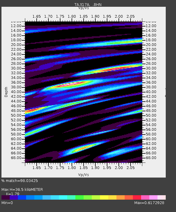
| Estimated Moho Depth: |
36.5 km |
| Estimated Crust Vp/Vs: |
1.79 |
| Assumed Crust Vp: |
6.207 km/s |
| Estimated Crust Vs: |
3.467 km/s |
| Estimated Crust Poisson's Ratio: |
0.27 |
|
| Radial Match: |
98.03425 % |
| Radial Bump: |
400 |
| Transverse Match: |
86.95377 % |
| Transverse Bump: |
400 |
| SOD ConfigId: |
2564 |
| Insert Time: |
2010-03-06 08:43:49.321 +0000 |
| GWidth: |
2.5 |
| Max Bumps: |
400 |
| Tol: |
0.001 |
|
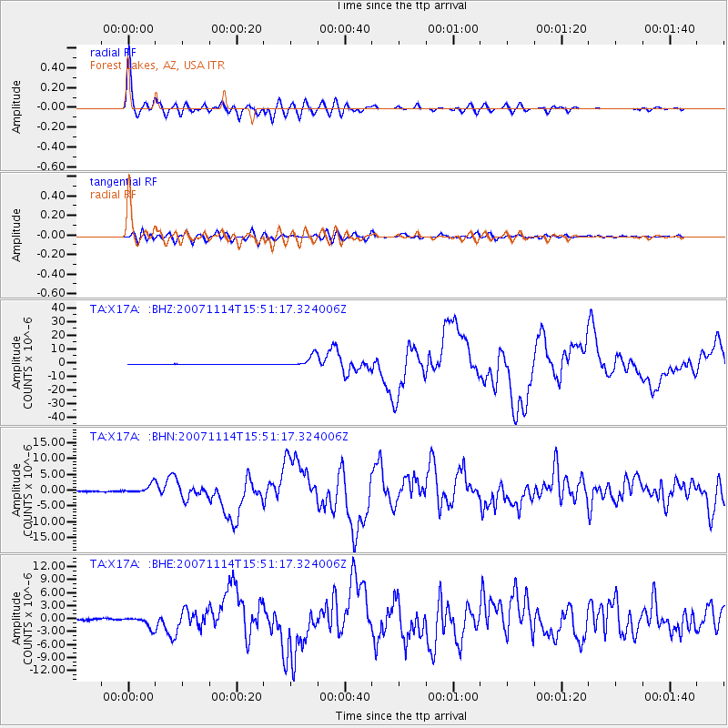
Signal To Noise
| Channel | StoN | STA | LTA |
| TA:X17A: :BHN:20071114T15:51:17.324006Z | 10.053152 | 1.5415029E-6 | 1.5333528E-7 |
| TA:X17A: :BHE:20071114T15:51:17.324006Z | 7.3717947 | 1.3850595E-6 | 1.8788633E-7 |
| TA:X17A: :BHZ:20071114T15:51:17.324006Z | 32.886486 | 4.416528E-6 | 1.3429614E-7 |
| Arrivals |
| Ps | 4.8 SECOND |
| PpPs | 16 SECOND |
| PsPs/PpSs | 21 SECOND |


