You are here: Home > Network List > TA - USArray Transportable Network (new EarthScope stations) Stations List
> Station E21K Killik River, AK, USA > Earthquake Result Viewer
E21K Killik River, AK, USA - Earthquake Result Viewer
| Earthquake location: |
Greenland Sea |
| Earthquake latitude/longitude: |
79.8/2.0 |
| Earthquake time(UTC): |
2018/02/08 (039) 02:29:14 GMT |
| Earthquake Depth: |
10 km |
| Earthquake Magnitude: |
5.6 Mww |
| Earthquake Catalog/Contributor: |
NEIC PDE/us |
|
| Network: |
TA USArray Transportable Network (new EarthScope stations) |
| Station: |
E21K Killik River, AK, USA |
| Lat/Lon: |
68.44 N/153.97 W |
| Elevation: |
653 m |
|
| Distance: |
31.3 deg |
| Az: |
343.197 deg |
| Baz: |
8.008 deg |
| Ray Param: |
0.079097964 |
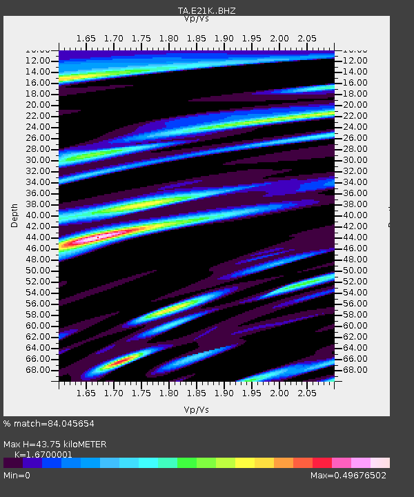
| Estimated Moho Depth: |
43.75 km |
| Estimated Crust Vp/Vs: |
1.67 |
| Assumed Crust Vp: |
6.221 km/s |
| Estimated Crust Vs: |
3.725 km/s |
| Estimated Crust Poisson's Ratio: |
0.22 |
|
| Radial Match: |
84.045654 % |
| Radial Bump: |
337 |
| Transverse Match: |
71.28266 % |
| Transverse Bump: |
400 |
| SOD ConfigId: |
13570011 |
| Insert Time: |
2019-04-29 18:12:47.965 +0000 |
| GWidth: |
2.5 |
| Max Bumps: |
400 |
| Tol: |
0.001 |
|

Signal To Noise
| Channel | StoN | STA | LTA |
| TA:E21K: :BHZ:20180208T02:35:04.40001Z | 1.7786797 | 2.0333744E-7 | 1.14319306E-7 |
| TA:E21K: :BHN:20180208T02:35:04.40001Z | 2.2390964 | 1.4187194E-7 | 6.336124E-8 |
| TA:E21K: :BHE:20180208T02:35:04.40001Z | 1.1315637 | 9.518829E-8 | 8.412102E-8 |
| Arrivals |
| Ps | 5.1 SECOND |
| PpPs | 17 SECOND |
| PsPs/PpSs | 22 SECOND |


