You are here: Home > Network List > TA - USArray Transportable Network (new EarthScope stations) Stations List
> Station X17A Forest Lakes, AZ, USA > Earthquake Result Viewer
X17A Forest Lakes, AZ, USA - Earthquake Result Viewer
*The percent match for this event was below the threshold and hence no stack was calculated.
| Earthquake location: |
Kuril Islands |
| Earthquake latitude/longitude: |
49.9/156.4 |
| Earthquake time(UTC): |
2008/08/04 (217) 04:42:14 GMT |
| Earthquake Depth: |
77 km |
| Earthquake Magnitude: |
5.6 MB, 5.8 MW, 5.7 MW |
| Earthquake Catalog/Contributor: |
WHDF/NEIC |
|
| Network: |
TA USArray Transportable Network (new EarthScope stations) |
| Station: |
X17A Forest Lakes, AZ, USA |
| Lat/Lon: |
34.34 N/110.81 W |
| Elevation: |
2280 m |
|
| Distance: |
66.3 deg |
| Az: |
64.489 deg |
| Baz: |
315.092 deg |
| Ray Param: |
$rayparam |
*The percent match for this event was below the threshold and hence was not used in the summary stack. |
|
| Radial Match: |
77.57837 % |
| Radial Bump: |
400 |
| Transverse Match: |
62.09048 % |
| Transverse Bump: |
400 |
| SOD ConfigId: |
2504 |
| Insert Time: |
2010-03-06 08:44:39.643 +0000 |
| GWidth: |
2.5 |
| Max Bumps: |
400 |
| Tol: |
0.001 |
|
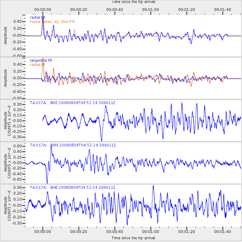
Signal To Noise
| Channel | StoN | STA | LTA |
| TA:X17A: :BHN:20080804T04:52:24.399011Z | 5.7549295 | 3.0503105E-7 | 5.3003436E-8 |
| TA:X17A: :BHE:20080804T04:52:24.399011Z | 1.5032685 | 9.8980514E-8 | 6.584354E-8 |
| TA:X17A: :BHZ:20080804T04:52:24.399011Z | 2.3426003 | 1.5378853E-7 | 6.564864E-8 |
| Arrivals |
| Ps | |
| PpPs | |
| PsPs/PpSs | |


