You are here: Home > Network List > US - United States National Seismic Network Stations List
> Station COWI Conover, Wisconsin, USA > Earthquake Result Viewer
COWI Conover, Wisconsin, USA - Earthquake Result Viewer
| Earthquake location: |
Near Coast Of Ecuador |
| Earthquake latitude/longitude: |
0.6/-80.3 |
| Earthquake time(UTC): |
2016/04/20 (111) 08:33:48 GMT |
| Earthquake Depth: |
16 km |
| Earthquake Magnitude: |
6.1 MO |
| Earthquake Catalog/Contributor: |
NEIC PDE/NEIC ALERT |
|
| Network: |
US United States National Seismic Network |
| Station: |
COWI Conover, Wisconsin, USA |
| Lat/Lon: |
46.10 N/89.14 W |
| Elevation: |
523 m |
|
| Distance: |
46.0 deg |
| Az: |
351.412 deg |
| Baz: |
167.608 deg |
| Ray Param: |
0.07091716 |
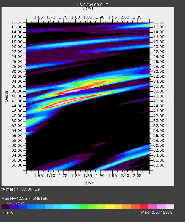
| Estimated Moho Depth: |
42.25 km |
| Estimated Crust Vp/Vs: |
1.75 |
| Assumed Crust Vp: |
6.467 km/s |
| Estimated Crust Vs: |
3.69 km/s |
| Estimated Crust Poisson's Ratio: |
0.26 |
|
| Radial Match: |
87.39719 % |
| Radial Bump: |
362 |
| Transverse Match: |
63.54471 % |
| Transverse Bump: |
400 |
| SOD ConfigId: |
1475611 |
| Insert Time: |
2016-05-04 08:50:25.241 +0000 |
| GWidth: |
2.5 |
| Max Bumps: |
400 |
| Tol: |
0.001 |
|

Signal To Noise
| Channel | StoN | STA | LTA |
| US:COWI:00:BHZ:20160420T08:41:39.399994Z | 3.1585193 | 4.0626122E-7 | 1.2862395E-7 |
| US:COWI:00:BH1:20160420T08:41:39.399994Z | 2.5860064 | 2.9808413E-7 | 1.15268136E-7 |
| US:COWI:00:BH2:20160420T08:41:39.399994Z | 1.3867934 | 1.3412377E-7 | 9.671503E-8 |
| Arrivals |
| Ps | 5.2 SECOND |
| PpPs | 17 SECOND |
| PsPs/PpSs | 22 SECOND |


