You are here: Home > Network List > TA - USArray Transportable Network (new EarthScope stations) Stations List
> Station X17A Forest Lakes, AZ, USA > Earthquake Result Viewer
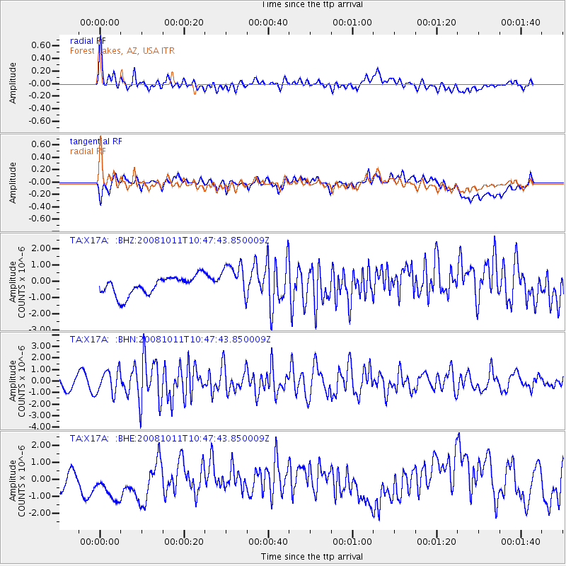
X17A Forest Lakes, AZ, USA - Earthquake Result Viewer
*The percent match for this event was below the threshold and hence no stack was calculated.
| Earthquake location: |
Virgin Islands |
| Earthquake latitude/longitude: |
19.2/-64.8 |
| Earthquake time(UTC): |
2008/10/11 (285) 10:40:14 GMT |
| Earthquake Depth: |
23 km |
| Earthquake Magnitude: |
6.1 MB, 5.9 MS, 6.1 MW, 6.0 MW |
| Earthquake Catalog/Contributor: |
WHDF/NEIC |
|
| Network: |
TA USArray Transportable Network (new EarthScope stations) |
| Station: |
X17A Forest Lakes, AZ, USA |
| Lat/Lon: |
34.34 N/110.81 W |
| Elevation: |
2280 m |
|
| Distance: |
43.4 deg |
| Az: |
299.972 deg |
| Baz: |
98.279 deg |
| Ray Param: |
$rayparam |
*The percent match for this event was below the threshold and hence was not used in the summary stack. |
|
| Radial Match: |
60.736034 % |
| Radial Bump: |
400 |
| Transverse Match: |
39.4607 % |
| Transverse Bump: |
400 |
| SOD ConfigId: |
2556 |
| Insert Time: |
2010-03-06 08:44:58.063 +0000 |
| GWidth: |
2.5 |
| Max Bumps: |
400 |
| Tol: |
0.001 |
|
Signal To Noise
| Channel | StoN | STA | LTA |
| TA:X17A: :BHN:20081011T10:47:43.850009Z | 1.9983635 | 1.0000574E-6 | 5.0043815E-7 |
| TA:X17A: :BHE:20081011T10:47:43.850009Z | 1.7605906 | 1.4732175E-6 | 8.3677463E-7 |
| TA:X17A: :BHZ:20081011T10:47:43.850009Z | 1.9400083 | 1.0944176E-6 | 5.6413035E-7 |
| Arrivals |
| Ps | |
| PpPs | |
| PsPs/PpSs | |


