You are here: Home > Network List > US - United States National Seismic Network Stations List
> Station HDIL Hopedale, Illinois, USA > Earthquake Result Viewer
HDIL Hopedale, Illinois, USA - Earthquake Result Viewer

| Earthquake location: |
Near Coast Of Ecuador |
| Earthquake latitude/longitude: |
0.6/-80.3 |
| Earthquake time(UTC): |
2016/04/20 (111) 08:33:48 GMT |
| Earthquake Depth: |
16 km |
| Earthquake Magnitude: |
6.1 MO |
| Earthquake Catalog/Contributor: |
NEIC PDE/NEIC ALERT |
|
| Network: |
US United States National Seismic Network |
| Station: |
HDIL Hopedale, Illinois, USA |
| Lat/Lon: |
40.56 N/89.29 W |
| Elevation: |
219 m |
|
| Distance: |
40.6 deg |
| Az: |
349.408 deg |
| Baz: |
166.04 deg |
| Ray Param: |
0.0742902 |
| Estimated Moho Depth: |
15.75 km |
| Estimated Crust Vp/Vs: |
2.10 |
| Assumed Crust Vp: |
6.498 km/s |
| Estimated Crust Vs: |
3.098 km/s |
| Estimated Crust Poisson's Ratio: |
0.35 |
|
| Radial Match: |
88.66172 % |
| Radial Bump: |
400 |
| Transverse Match: |
41.363323 % |
| Transverse Bump: |
400 |
| SOD ConfigId: |
1475611 |
| Insert Time: |
2016-05-04 08:51:33.259 +0000 |
| GWidth: |
2.5 |
| Max Bumps: |
400 |
| Tol: |
0.001 |
|
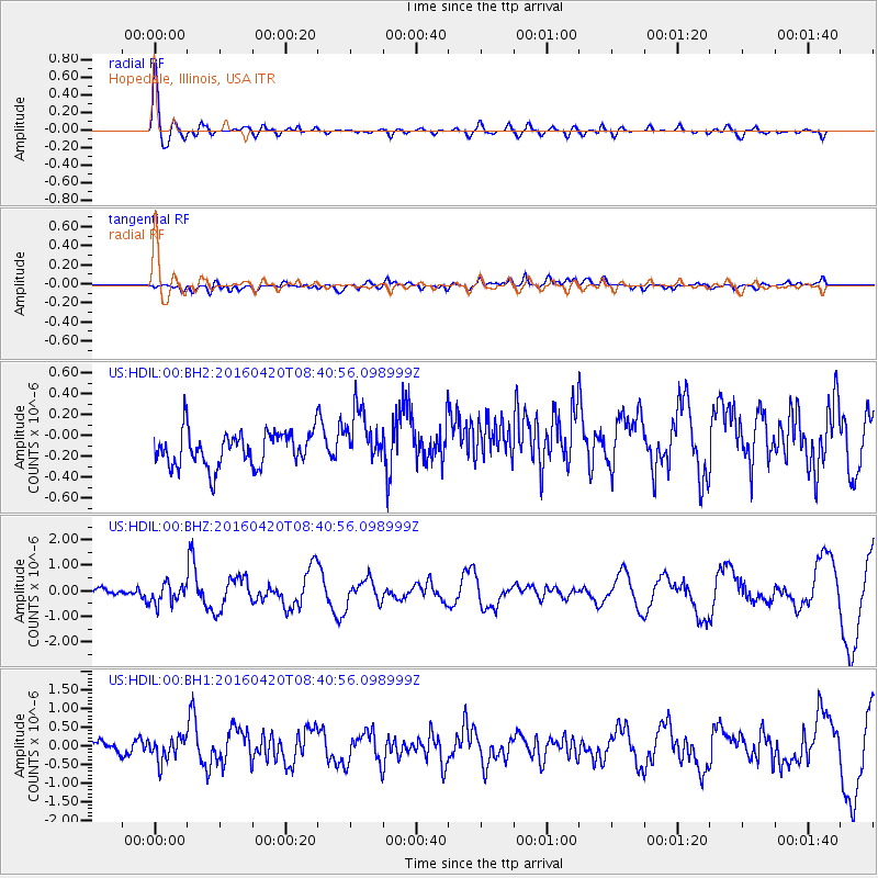
Signal To Noise
| Channel | StoN | STA | LTA |
| US:HDIL:00:BHZ:20160420T08:40:56.098999Z | 3.4873154 | 3.8790554E-7 | 1.11233284E-7 |
| US:HDIL:00:BH1:20160420T08:40:56.098999Z | 1.7860407 | 3.0476394E-7 | 1.7063662E-7 |
| US:HDIL:00:BH2:20160420T08:40:56.098999Z | 1.5884513 | 2.6196795E-7 | 1.6492035E-7 |
| Arrivals |
| Ps | 2.8 SECOND |
| PpPs | 7.1 SECOND |
| PsPs/PpSs | 9.9 SECOND |


