You are here: Home > Network List > TA - USArray Transportable Network (new EarthScope stations) Stations List
> Station X17A Forest Lakes, AZ, USA > Earthquake Result Viewer
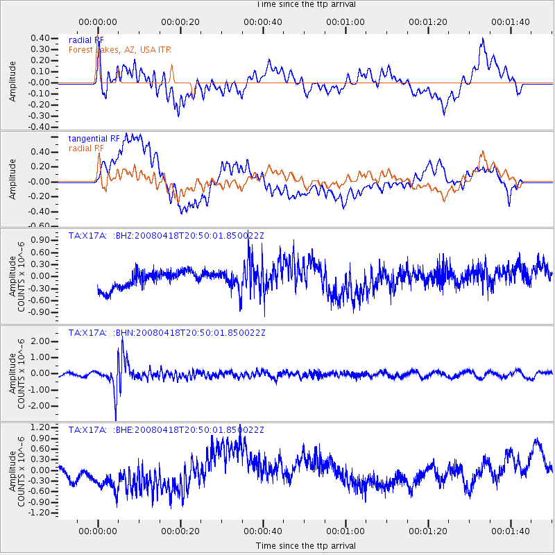
X17A Forest Lakes, AZ, USA - Earthquake Result Viewer
*The percent match for this event was below the threshold and hence no stack was calculated.
| Earthquake location: |
Fiji Islands Region |
| Earthquake latitude/longitude: |
-17.3/-179.0 |
| Earthquake time(UTC): |
2008/04/18 (109) 20:39:07 GMT |
| Earthquake Depth: |
554 km |
| Earthquake Magnitude: |
5.9 MB, 6.3 MW, 6.3 MW |
| Earthquake Catalog/Contributor: |
WHDF/NEIC |
|
| Network: |
TA USArray Transportable Network (new EarthScope stations) |
| Station: |
X17A Forest Lakes, AZ, USA |
| Lat/Lon: |
34.34 N/110.81 W |
| Elevation: |
2280 m |
|
| Distance: |
82.7 deg |
| Az: |
50.775 deg |
| Baz: |
243.398 deg |
| Ray Param: |
$rayparam |
*The percent match for this event was below the threshold and hence was not used in the summary stack. |
|
| Radial Match: |
57.88461 % |
| Radial Bump: |
400 |
| Transverse Match: |
26.925463 % |
| Transverse Bump: |
400 |
| SOD ConfigId: |
2504 |
| Insert Time: |
2010-03-06 08:45:25.649 +0000 |
| GWidth: |
2.5 |
| Max Bumps: |
400 |
| Tol: |
0.001 |
|
Signal To Noise
| Channel | StoN | STA | LTA |
| TA:X17A: :BHN:20080418T20:50:01.850022Z | 5.884676 | 7.7834926E-7 | 1.3226715E-7 |
| TA:X17A: :BHE:20080418T20:50:01.850022Z | 1.5712079 | 8.3855116E-7 | 5.336984E-7 |
| TA:X17A: :BHZ:20080418T20:50:01.850022Z | 1.1670238 | 2.4077679E-7 | 2.0631697E-7 |
| Arrivals |
| Ps | |
| PpPs | |
| PsPs/PpSs | |


