You are here: Home > Network List > TA - USArray Transportable Network (new EarthScope stations) Stations List
> Station X17A Forest Lakes, AZ, USA > Earthquake Result Viewer
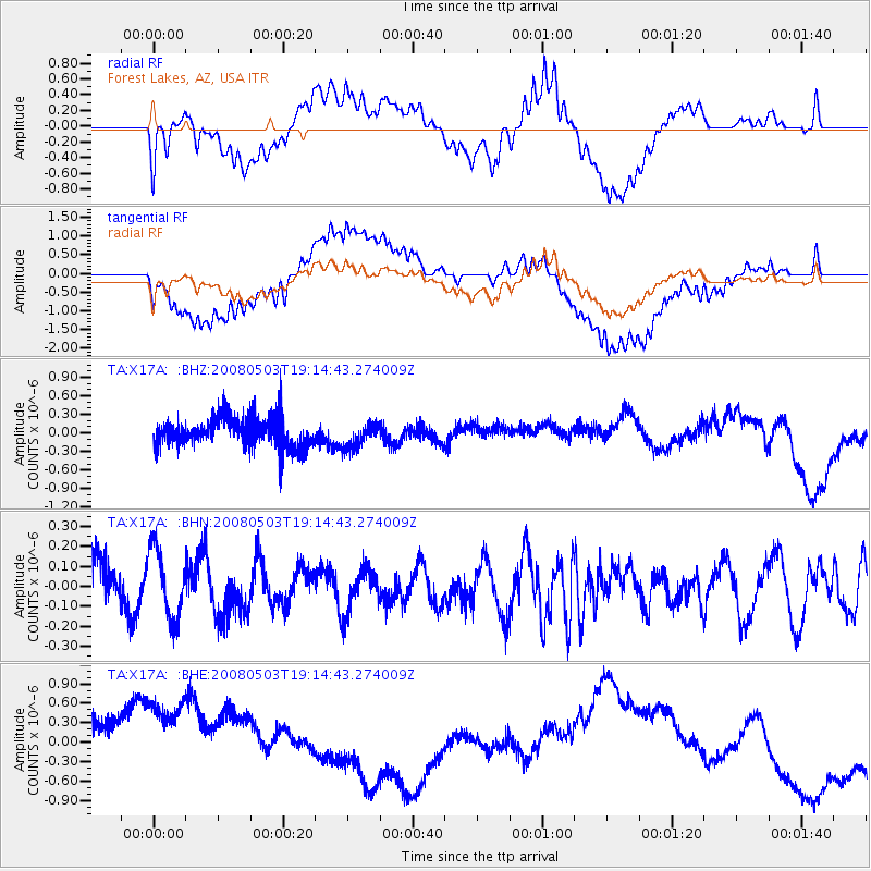
X17A Forest Lakes, AZ, USA - Earthquake Result Viewer
*The percent match for this event was below the threshold and hence no stack was calculated.
| Earthquake location: |
Solomon Islands |
| Earthquake latitude/longitude: |
-6.6/155.1 |
| Earthquake time(UTC): |
2008/05/03 (124) 19:01:46 GMT |
| Earthquake Depth: |
35 km |
| Earthquake Magnitude: |
5.8 MW, 5.4 MS, 5.4 MB, 5.7 MW |
| Earthquake Catalog/Contributor: |
WHDF/NEIC |
|
| Network: |
TA USArray Transportable Network (new EarthScope stations) |
| Station: |
X17A Forest Lakes, AZ, USA |
| Lat/Lon: |
34.34 N/110.81 W |
| Elevation: |
2280 m |
|
| Distance: |
97.1 deg |
| Az: |
56.276 deg |
| Baz: |
266.815 deg |
| Ray Param: |
$rayparam |
*The percent match for this event was below the threshold and hence was not used in the summary stack. |
|
| Radial Match: |
55.27493 % |
| Radial Bump: |
400 |
| Transverse Match: |
42.672413 % |
| Transverse Bump: |
400 |
| SOD ConfigId: |
2504 |
| Insert Time: |
2010-03-06 08:45:27.540 +0000 |
| GWidth: |
2.5 |
| Max Bumps: |
400 |
| Tol: |
0.001 |
|
Signal To Noise
| Channel | StoN | STA | LTA |
| TA:X17A: :BHN:20080503T19:14:43.274009Z | 1.3799107 | 1.7293279E-7 | 1.2532172E-7 |
| TA:X17A: :BHE:20080503T19:14:43.274009Z | 1.8573126 | 1.1447148E-6 | 6.1632863E-7 |
| TA:X17A: :BHZ:20080503T19:14:43.274009Z | 0.85957783 | 1.9767162E-7 | 2.2996362E-7 |
| Arrivals |
| Ps | |
| PpPs | |
| PsPs/PpSs | |


