You are here: Home > Network List > TA - USArray Transportable Network (new EarthScope stations) Stations List
> Station X17A Forest Lakes, AZ, USA > Earthquake Result Viewer
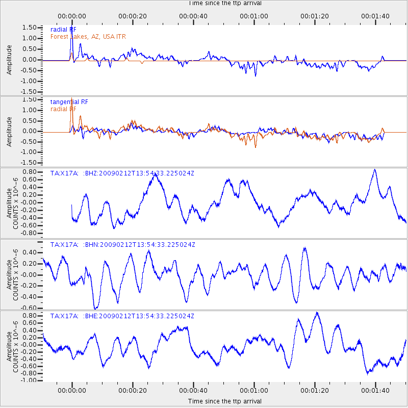
X17A Forest Lakes, AZ, USA - Earthquake Result Viewer
*The percent match for this event was below the threshold and hence no stack was calculated.
| Earthquake location: |
South Of Mariana Islands |
| Earthquake latitude/longitude: |
12.1/143.8 |
| Earthquake time(UTC): |
2009/02/12 (043) 13:41:43 GMT |
| Earthquake Depth: |
40 km |
| Earthquake Magnitude: |
5.5 MB |
| Earthquake Catalog/Contributor: |
WHDF/NEIC |
|
| Network: |
TA USArray Transportable Network (new EarthScope stations) |
| Station: |
X17A Forest Lakes, AZ, USA |
| Lat/Lon: |
34.34 N/110.81 W |
| Elevation: |
2280 m |
|
| Distance: |
95.6 deg |
| Az: |
53.276 deg |
| Baz: |
288.7 deg |
| Ray Param: |
$rayparam |
*The percent match for this event was below the threshold and hence was not used in the summary stack. |
|
| Radial Match: |
66.46344 % |
| Radial Bump: |
400 |
| Transverse Match: |
64.928276 % |
| Transverse Bump: |
400 |
| SOD ConfigId: |
2658 |
| Insert Time: |
2010-03-06 08:45:54.307 +0000 |
| GWidth: |
2.5 |
| Max Bumps: |
400 |
| Tol: |
0.001 |
|
Signal To Noise
| Channel | StoN | STA | LTA |
| TA:X17A: :BHN:20090212T13:54:33.225024Z | 0.5892617 | 1.2681737E-7 | 2.15214E-7 |
| TA:X17A: :BHE:20090212T13:54:33.225024Z | 1.917409 | 4.72905E-7 | 2.4663754E-7 |
| TA:X17A: :BHZ:20090212T13:54:33.225024Z | 1.8390815 | 4.5578423E-7 | 2.4783253E-7 |
| Arrivals |
| Ps | |
| PpPs | |
| PsPs/PpSs | |


