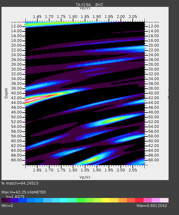
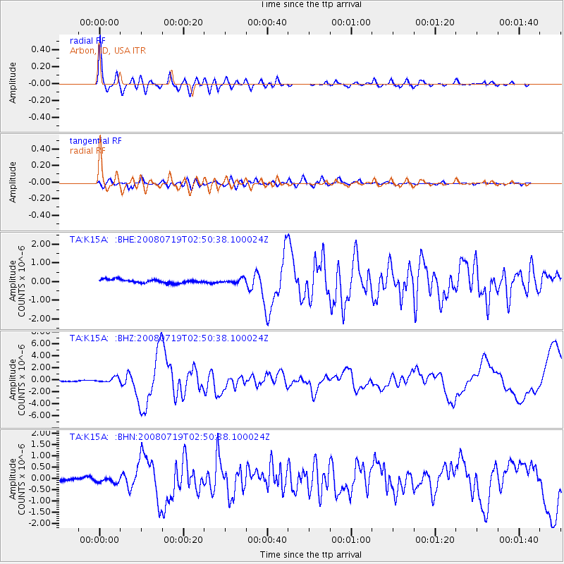
K15A Arbon, ID, USA - Earthquake Result Viewer

Earthquake location: Off East Coast Of Honshu, Japan
Earthquake latitude/longitude: 37.6/142.2
Earthquake time(UTC): 2008/07/19 (201) 02:39:28 GMT
Earthquake Depth: 22 km
Earthquake Magnitude: 6.2 MB, 7.0 MS, 7.0 MW, 6.9 MW
Earthquake Catalog/Contributor: WHDF/NEIC
Network: TA USArray Transportable Network (new EarthScope stations)
Station: K15A Arbon, ID, USA
Lat/Lon: 42.69 N/112.53 W
Elevation: 1566 m
Distance: 75.2 deg
Az: 47.379 deg
Baz: 307.519 deg
Ray Param: 0.0518175
Estimated Moho Depth: 42.25 km
Estimated Crust Vp/Vs: 1.64
Assumed Crust Vp: 6.279 km/s
Estimated Crust Vs: 3.834 km/s
Estimated Crust Poisson's Ratio: 0.20
Radial Match: 94.24515 %
Radial Bump: 400
Transverse Match: 85.36976 %
Transverse Bump: 400
SOD ConfigId: 2504
Insert Time: 2010-03-06 08:46:11.374 +0000
GWidth: 2.5
Max Bumps: 400
Tol: 0.001

Signal To Noise

ChannelStoNSTALTA
TA:K15A: :BHZ:20080719T02:50:38.100024Z5.7717244.4935777E-77.785503E-8
TA:K15A: :BHN:20080719T02:50:38.100024Z1.44049951.7216331E-71.1951639E-7
TA:K15A: :BHE:20080719T02:50:38.100024Z1.19975661.12849214E-79.406009E-8
Arrivals
Ps4.4 SECOND
PpPs17 SECOND
PsPs/PpSs22 SECOND