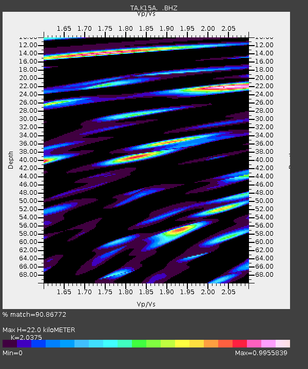
K15A Arbon, ID, USA - Earthquake Result Viewer
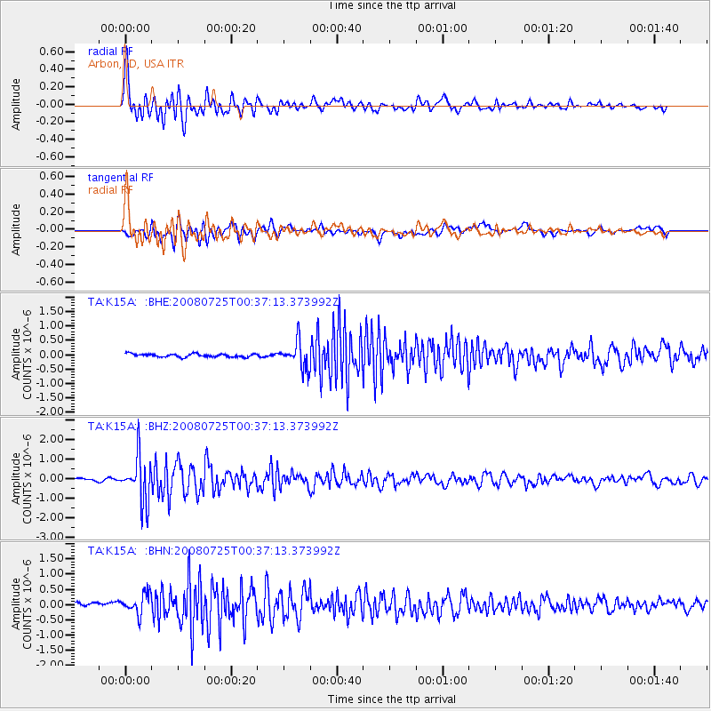
Earthquake location: Rat Islands, Aleutian Islands
Earthquake latitude/longitude: 51.3/179.0
Earthquake time(UTC): 2008/07/25 (207) 00:29:22 GMT
Earthquake Depth: 21 km
Earthquake Magnitude: 5.7 MB, 5.5 MS, 5.9 MW, 5.9 MW
Earthquake Catalog/Contributor: WHDF/NEIC
Network: TA USArray Transportable Network (new EarthScope stations)
Station: K15A Arbon, ID, USA
Lat/Lon: 42.69 N/112.53 W
Elevation: 1566 m
Distance: 45.9 deg
Az: 72.684 deg
Baz: 305.59 deg
Ray Param: 0.070927545
Estimated Moho Depth: 22.0 km
Estimated Crust Vp/Vs: 2.04
Assumed Crust Vp: 6.279 km/s
Estimated Crust Vs: 3.082 km/s
Estimated Crust Poisson's Ratio: 0.34
Radial Match: 90.86772 %
Radial Bump: 400
Transverse Match: 80.42324 %
Transverse Bump: 400
SOD ConfigId: 2504
Insert Time: 2010-03-06 08:46:15.534 +0000
GWidth: 2.5
Max Bumps: 400
Tol: 0.001

Signal To Noise

ChannelStoNSTALTA
TA:K15A: :BHZ:20080725T00:37:13.373992Z17.6158521.1880655E-66.744298E-8
TA:K15A: :BHN:20080725T00:37:13.373992Z4.40313243.337339E-77.579466E-8
TA:K15A: :BHE:20080725T00:37:13.373992Z8.4494624.6683593E-75.525037E-8
Arrivals
Ps3.8 SECOND
PpPs10 SECOND
PsPs/PpSs14 SECOND