You are here: Home > Network List > TA - USArray Transportable Network (new EarthScope stations) Stations List
> Station A36M Sachs Harbour, NT, CAN > Earthquake Result Viewer
A36M Sachs Harbour, NT, CAN - Earthquake Result Viewer
| Earthquake location: |
Andreanof Islands, Aleutian Is. |
| Earthquake latitude/longitude: |
52.6/-179.5 |
| Earthquake time(UTC): |
2018/02/08 (039) 11:04:01 GMT |
| Earthquake Depth: |
211 km |
| Earthquake Magnitude: |
5.6 Mww |
| Earthquake Catalog/Contributor: |
NEIC PDE/us |
|
| Network: |
TA USArray Transportable Network (new EarthScope stations) |
| Station: |
A36M Sachs Harbour, NT, CAN |
| Lat/Lon: |
71.99 N/125.25 W |
| Elevation: |
32 m |
|
| Distance: |
30.2 deg |
| Az: |
30.063 deg |
| Baz: |
259.376 deg |
| Ray Param: |
0.078936175 |
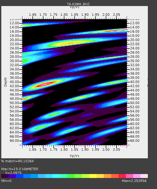
| Estimated Moho Depth: |
15.0 km |
| Estimated Crust Vp/Vs: |
2.10 |
| Assumed Crust Vp: |
6.24 km/s |
| Estimated Crust Vs: |
2.975 km/s |
| Estimated Crust Poisson's Ratio: |
0.35 |
|
| Radial Match: |
90.10364 % |
| Radial Bump: |
306 |
| Transverse Match: |
75.11159 % |
| Transverse Bump: |
400 |
| SOD ConfigId: |
13570011 |
| Insert Time: |
2019-04-29 18:23:49.351 +0000 |
| GWidth: |
2.5 |
| Max Bumps: |
400 |
| Tol: |
0.001 |
|
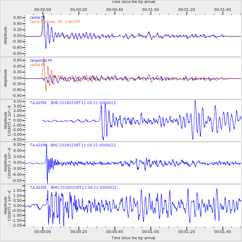
Signal To Noise
| Channel | StoN | STA | LTA |
| TA:A36M: :BHZ:20180208T11:09:22.000002Z | 25.607502 | 3.3432204E-6 | 1.3055629E-7 |
| TA:A36M: :BHN:20180208T11:09:22.000002Z | 4.544899 | 6.7543095E-7 | 1.4861298E-7 |
| TA:A36M: :BHE:20180208T11:09:22.000002Z | 16.02111 | 2.0801237E-6 | 1.2983644E-7 |
| Arrivals |
| Ps | 2.8 SECOND |
| PpPs | 7.0 SECOND |
| PsPs/PpSs | 9.8 SECOND |


