You are here: Home > Network List > TA - USArray Transportable Network (new EarthScope stations) Stations List
> Station K15A Arbon, ID, USA > Earthquake Result Viewer
K15A Arbon, ID, USA - Earthquake Result Viewer
| Earthquake location: |
Central East Pacific Rise |
| Earthquake latitude/longitude: |
-4.6/-106.0 |
| Earthquake time(UTC): |
2008/09/18 (262) 01:41:02 GMT |
| Earthquake Depth: |
10 km |
| Earthquake Magnitude: |
5.5 MB, 5.7 MS, 6.0 MW, 6.0 MW |
| Earthquake Catalog/Contributor: |
WHDF/NEIC |
|
| Network: |
TA USArray Transportable Network (new EarthScope stations) |
| Station: |
K15A Arbon, ID, USA |
| Lat/Lon: |
42.69 N/112.53 W |
| Elevation: |
1566 m |
|
| Distance: |
47.4 deg |
| Az: |
353.457 deg |
| Baz: |
171.138 deg |
| Ray Param: |
0.070021436 |
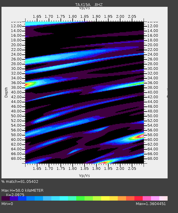
| Estimated Moho Depth: |
58.0 km |
| Estimated Crust Vp/Vs: |
2.10 |
| Assumed Crust Vp: |
6.279 km/s |
| Estimated Crust Vs: |
2.993 km/s |
| Estimated Crust Poisson's Ratio: |
0.35 |
|
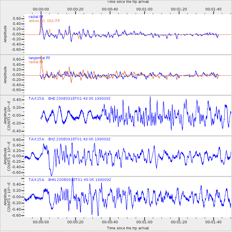
| Radial Match: |
81.05402 % |
| Radial Bump: |
400 |
| Transverse Match: |
55.96147 % |
| Transverse Bump: |
400 |
| SOD ConfigId: |
2504 |
| Insert Time: |
2010-03-06 08:46:40.411 +0000 |
| GWidth: |
2.5 |
| Max Bumps: |
400 |
| Tol: |
0.001 |
|
Signal To Noise
| Channel | StoN | STA | LTA |
| TA:K15A: :BHZ:20080918T01:49:06.199009Z | 4.5625377 | 2.535991E-7 | 5.5582905E-8 |
| TA:K15A: :BHN:20080918T01:49:06.199009Z | 1.9635662 | 1.4807448E-7 | 7.5410995E-8 |
| TA:K15A: :BHE:20080918T01:49:06.199009Z | 0.5034656 | 5.2006065E-8 | 1.03296166E-7 |
| Arrivals |
| Ps | 11 SECOND |
| PpPs | 27 SECOND |
| PsPs/PpSs | 38 SECOND |


