You are here: Home > Network List > TA - USArray Transportable Network (new EarthScope stations) Stations List
> Station K15A Arbon, ID, USA > Earthquake Result Viewer
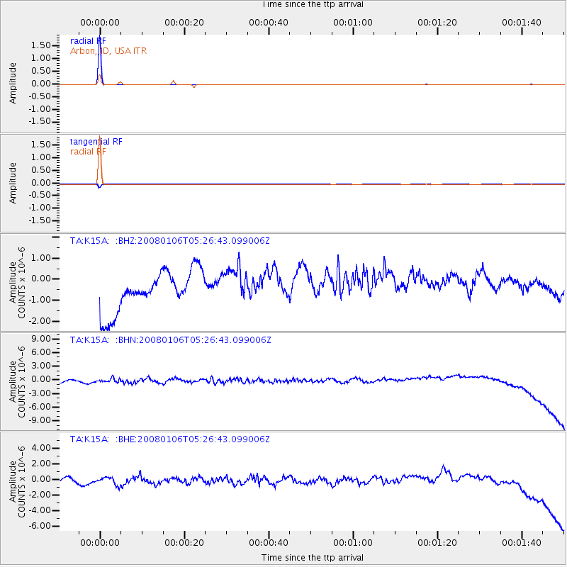
K15A Arbon, ID, USA - Earthquake Result Viewer
| Earthquake location: |
Southern Greece |
| Earthquake latitude/longitude: |
37.2/22.7 |
| Earthquake time(UTC): |
2008/01/06 (006) 05:14:20 GMT |
| Earthquake Depth: |
75 km |
| Earthquake Magnitude: |
6.1 MB, 6.2 MW, 6.1 MW |
| Earthquake Catalog/Contributor: |
WHDF/NEIC |
|
| Network: |
TA USArray Transportable Network (new EarthScope stations) |
| Station: |
K15A Arbon, ID, USA |
| Lat/Lon: |
42.69 N/112.53 W |
| Elevation: |
1566 m |
|
| Distance: |
90.6 deg |
| Az: |
328.709 deg |
| Baz: |
34.216 deg |
| Ray Param: |
0.041645907 |
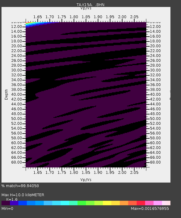
| Estimated Moho Depth: |
10.0 km |
| Estimated Crust Vp/Vs: |
1.60 |
| Assumed Crust Vp: |
6.279 km/s |
| Estimated Crust Vs: |
3.924 km/s |
| Estimated Crust Poisson's Ratio: |
0.18 |
|
| Radial Match: |
99.94058 % |
| Radial Bump: |
22 |
| Transverse Match: |
96.90005 % |
| Transverse Bump: |
75 |
| SOD ConfigId: |
2564 |
| Insert Time: |
2010-03-06 08:46:49.710 +0000 |
| GWidth: |
2.5 |
| Max Bumps: |
400 |
| Tol: |
0.001 |
|
Signal To Noise
| Channel | StoN | STA | LTA |
| TA:K15A: :BHN:20080106T05:26:43.099006Z | 0.74555904 | 7.189456E-7 | 9.643041E-7 |
| TA:K15A: :BHE:20080106T05:26:43.099006Z | 1.0868365 | 6.40347E-7 | 5.8918437E-7 |
| TA:K15A: :BHZ:20080106T05:26:43.099006Z | 0.9908785 | 9.1489534E-7 | 9.233173E-7 |
| Arrivals |
| Ps | 1.0 SECOND |
| PpPs | 4.1 SECOND |
| PsPs/PpSs | 5.0 SECOND |


