You are here: Home > Network List > UW - Pacific Northwest Regional Seismic Network Stations List
> Station LEBA Lebam, WA, USA > Earthquake Result Viewer
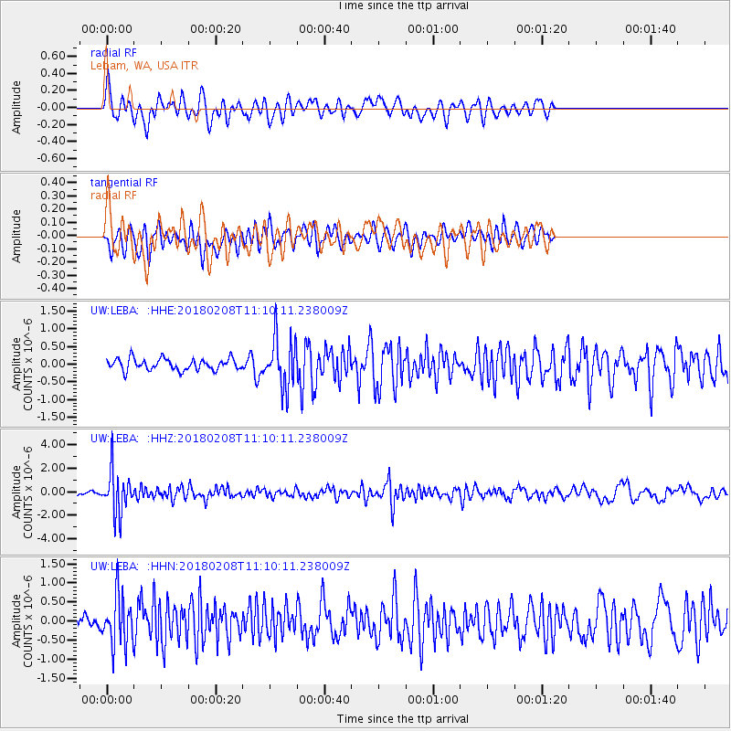
LEBA Lebam, WA, USA - Earthquake Result Viewer
*The percent match for this event was below the threshold and hence no stack was calculated.
| Earthquake location: |
Andreanof Islands, Aleutian Is. |
| Earthquake latitude/longitude: |
52.6/-179.5 |
| Earthquake time(UTC): |
2018/02/08 (039) 11:04:01 GMT |
| Earthquake Depth: |
211 km |
| Earthquake Magnitude: |
5.6 Mww |
| Earthquake Catalog/Contributor: |
NEIC PDE/us |
|
| Network: |
UW Pacific Northwest Regional Seismic Network |
| Station: |
LEBA Lebam, WA, USA |
| Lat/Lon: |
46.55 N/123.56 W |
| Elevation: |
73 m |
|
| Distance: |
36.0 deg |
| Az: |
76.699 deg |
| Baz: |
300.61 deg |
| Ray Param: |
$rayparam |
*The percent match for this event was below the threshold and hence was not used in the summary stack. |
|
| Radial Match: |
68.16259 % |
| Radial Bump: |
400 |
| Transverse Match: |
64.17174 % |
| Transverse Bump: |
400 |
| SOD ConfigId: |
13570011 |
| Insert Time: |
2019-04-29 18:25:21.611 +0000 |
| GWidth: |
2.5 |
| Max Bumps: |
400 |
| Tol: |
0.001 |
|
Signal To Noise
| Channel | StoN | STA | LTA |
| UW:LEBA: :HHZ:20180208T11:10:11.238009Z | 10.623887 | 1.8186684E-6 | 1.7118673E-7 |
| UW:LEBA: :HHN:20180208T11:10:11.238009Z | 4.3937535 | 6.767146E-7 | 1.5401743E-7 |
| UW:LEBA: :HHE:20180208T11:10:11.238009Z | 4.361561 | 7.08618E-7 | 1.6246891E-7 |
| Arrivals |
| Ps | |
| PpPs | |
| PsPs/PpSs | |


