You are here: Home > Network List > TA - USArray Transportable Network (new EarthScope stations) Stations List
> Station K15A Arbon, ID, USA > Earthquake Result Viewer
K15A Arbon, ID, USA - Earthquake Result Viewer
| Earthquake location: |
Volcano Islands, Japan Region |
| Earthquake latitude/longitude: |
22.0/142.7 |
| Earthquake time(UTC): |
2007/09/28 (271) 13:38:59 GMT |
| Earthquake Depth: |
276 km |
| Earthquake Magnitude: |
6.7 MB, 7.4 MW, 7.4 MW |
| Earthquake Catalog/Contributor: |
WHDF/NEIC |
|
| Network: |
TA USArray Transportable Network (new EarthScope stations) |
| Station: |
K15A Arbon, ID, USA |
| Lat/Lon: |
42.69 N/112.53 W |
| Elevation: |
1566 m |
|
| Distance: |
85.6 deg |
| Az: |
45.638 deg |
| Baz: |
295.867 deg |
| Ray Param: |
0.043967832 |
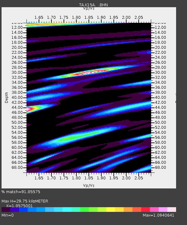
| Estimated Moho Depth: |
29.75 km |
| Estimated Crust Vp/Vs: |
1.86 |
| Assumed Crust Vp: |
6.279 km/s |
| Estimated Crust Vs: |
3.38 km/s |
| Estimated Crust Poisson's Ratio: |
0.30 |
|
| Radial Match: |
91.85575 % |
| Radial Bump: |
400 |
| Transverse Match: |
80.070564 % |
| Transverse Bump: |
400 |
| SOD ConfigId: |
2564 |
| Insert Time: |
2010-03-06 08:47:03.014 +0000 |
| GWidth: |
2.5 |
| Max Bumps: |
400 |
| Tol: |
0.001 |
|
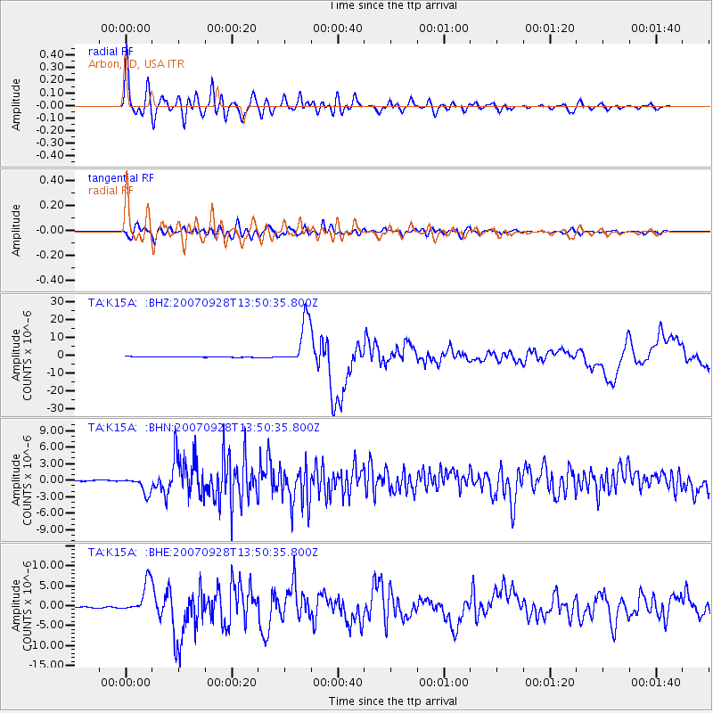
Signal To Noise
| Channel | StoN | STA | LTA |
| TA:K15A: :BHN:20070928T13:50:35.800Z | 13.16387 | 1.4905138E-6 | 1.13227635E-7 |
| TA:K15A: :BHE:20070928T13:50:35.800Z | 43.74664 | 4.03513E-6 | 9.223863E-8 |
| TA:K15A: :BHZ:20070928T13:50:35.800Z | 93.91725 | 1.3027956E-5 | 1.387174E-7 |
| Arrivals |
| Ps | 4.1 SECOND |
| PpPs | 13 SECOND |
| PsPs/PpSs | 17 SECOND |


