You are here: Home > Network List > TA - USArray Transportable Network (new EarthScope stations) Stations List
> Station K15A Arbon, ID, USA > Earthquake Result Viewer
K15A Arbon, ID, USA - Earthquake Result Viewer
| Earthquake location: |
Solomon Islands |
| Earthquake latitude/longitude: |
-9.8/159.5 |
| Earthquake time(UTC): |
2007/08/16 (228) 08:39:27 GMT |
| Earthquake Depth: |
10 km |
| Earthquake Magnitude: |
6.1 MB, 6.7 MS, 6.4 MW |
| Earthquake Catalog/Contributor: |
WHDF/NEIC |
|
| Network: |
TA USArray Transportable Network (new EarthScope stations) |
| Station: |
K15A Arbon, ID, USA |
| Lat/Lon: |
42.69 N/112.53 W |
| Elevation: |
1566 m |
|
| Distance: |
95.1 deg |
| Az: |
47.719 deg |
| Baz: |
261.439 deg |
| Ray Param: |
0.040866703 |
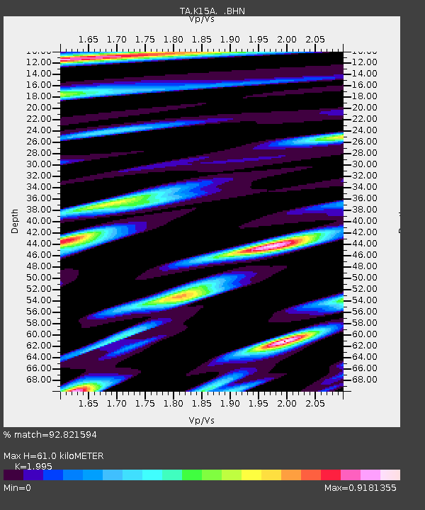
| Estimated Moho Depth: |
61.0 km |
| Estimated Crust Vp/Vs: |
2.00 |
| Assumed Crust Vp: |
6.279 km/s |
| Estimated Crust Vs: |
3.147 km/s |
| Estimated Crust Poisson's Ratio: |
0.33 |
|
| Radial Match: |
92.821594 % |
| Radial Bump: |
400 |
| Transverse Match: |
88.22152 % |
| Transverse Bump: |
400 |
| SOD ConfigId: |
2564 |
| Insert Time: |
2010-03-06 08:47:14.944 +0000 |
| GWidth: |
2.5 |
| Max Bumps: |
400 |
| Tol: |
0.001 |
|
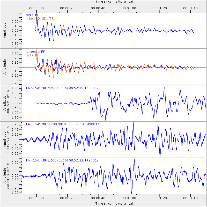
Signal To Noise
| Channel | StoN | STA | LTA |
| TA:K15A: :BHN:20070816T08:52:19.149001Z | 1.7353424 | 5.172378E-8 | 2.9806095E-8 |
| TA:K15A: :BHE:20070816T08:52:19.149001Z | 1.4702853 | 6.7514655E-8 | 4.5919425E-8 |
| TA:K15A: :BHZ:20070816T08:52:19.149001Z | 1.9926592 | 9.244544E-8 | 4.6392998E-8 |
| Arrivals |
| Ps | 9.8 SECOND |
| PpPs | 29 SECOND |
| PsPs/PpSs | 38 SECOND |


