You are here: Home > Network List > TA - USArray Transportable Network (new EarthScope stations) Stations List
> Station K15A Arbon, ID, USA > Earthquake Result Viewer
K15A Arbon, ID, USA - Earthquake Result Viewer
| Earthquake location: |
Andreanof Islands, Aleutian Is. |
| Earthquake latitude/longitude: |
50.2/-177.6 |
| Earthquake time(UTC): |
2007/08/16 (228) 04:03:03 GMT |
| Earthquake Depth: |
15 km |
| Earthquake Magnitude: |
5.8 MB |
| Earthquake Catalog/Contributor: |
WHDF/NEIC |
|
| Network: |
TA USArray Transportable Network (new EarthScope stations) |
| Station: |
K15A Arbon, ID, USA |
| Lat/Lon: |
42.69 N/112.53 W |
| Elevation: |
1566 m |
|
| Distance: |
44.1 deg |
| Az: |
73.725 deg |
| Baz: |
303.292 deg |
| Ray Param: |
0.07208995 |
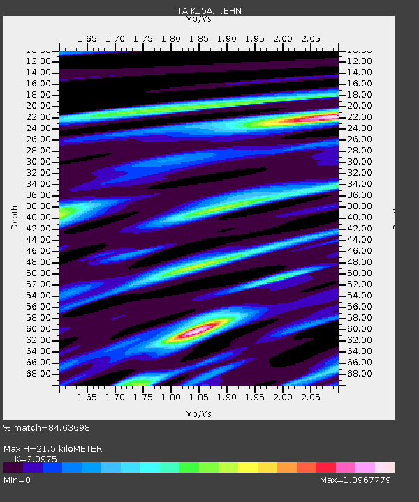
| Estimated Moho Depth: |
21.5 km |
| Estimated Crust Vp/Vs: |
2.10 |
| Assumed Crust Vp: |
6.279 km/s |
| Estimated Crust Vs: |
2.993 km/s |
| Estimated Crust Poisson's Ratio: |
0.35 |
|
| Radial Match: |
84.63698 % |
| Radial Bump: |
400 |
| Transverse Match: |
72.98188 % |
| Transverse Bump: |
400 |
| SOD ConfigId: |
2564 |
| Insert Time: |
2010-03-06 08:47:16.611 +0000 |
| GWidth: |
2.5 |
| Max Bumps: |
400 |
| Tol: |
0.001 |
|
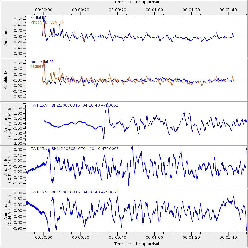
Signal To Noise
| Channel | StoN | STA | LTA |
| TA:K15A: :BHN:20070816T04:10:40.475006Z | 1.2043123 | 3.162334E-7 | 2.6258422E-7 |
| TA:K15A: :BHE:20070816T04:10:40.475006Z | 1.9364042 | 5.312633E-7 | 2.7435559E-7 |
| TA:K15A: :BHZ:20070816T04:10:40.475006Z | 5.9463162 | 1.0575525E-6 | 1.7785003E-7 |
| Arrivals |
| Ps | 4.0 SECOND |
| PpPs | 10 SECOND |
| PsPs/PpSs | 14 SECOND |


