You are here: Home > Network List > TA - USArray Transportable Network (new EarthScope stations) Stations List
> Station K15A Arbon, ID, USA > Earthquake Result Viewer
K15A Arbon, ID, USA - Earthquake Result Viewer
| Earthquake location: |
Near Coast Of Peru |
| Earthquake latitude/longitude: |
-13.4/-76.6 |
| Earthquake time(UTC): |
2007/08/15 (227) 23:40:57 GMT |
| Earthquake Depth: |
39 km |
| Earthquake Magnitude: |
6.7 MB, 7.9 MS, 8.0 MW, 7.5 ME |
| Earthquake Catalog/Contributor: |
WHDF/NEIC |
|
| Network: |
TA USArray Transportable Network (new EarthScope stations) |
| Station: |
K15A Arbon, ID, USA |
| Lat/Lon: |
42.69 N/112.53 W |
| Elevation: |
1566 m |
|
| Distance: |
64.8 deg |
| Az: |
331.437 deg |
| Baz: |
140.872 deg |
| Ray Param: |
0.05861531 |
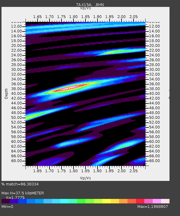
| Estimated Moho Depth: |
37.5 km |
| Estimated Crust Vp/Vs: |
1.78 |
| Assumed Crust Vp: |
6.279 km/s |
| Estimated Crust Vs: |
3.532 km/s |
| Estimated Crust Poisson's Ratio: |
0.27 |
|
| Radial Match: |
96.38334 % |
| Radial Bump: |
400 |
| Transverse Match: |
89.59081 % |
| Transverse Bump: |
400 |
| SOD ConfigId: |
2564 |
| Insert Time: |
2010-03-06 08:47:20.023 +0000 |
| GWidth: |
2.5 |
| Max Bumps: |
400 |
| Tol: |
0.001 |
|
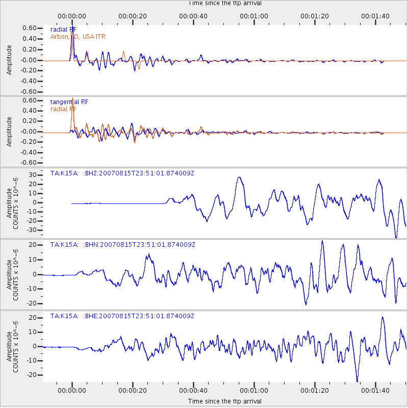
Signal To Noise
| Channel | StoN | STA | LTA |
| TA:K15A: :BHN:20070815T23:51:01.874009Z | 23.447989 | 1.2954098E-6 | 5.524609E-8 |
| TA:K15A: :BHE:20070815T23:51:01.874009Z | 17.24779 | 1.0624377E-6 | 6.1598485E-8 |
| TA:K15A: :BHZ:20070815T23:51:01.874009Z | 23.469091 | 3.0546526E-6 | 1.301564E-7 |
| Arrivals |
| Ps | 4.8 SECOND |
| PpPs | 16 SECOND |
| PsPs/PpSs | 21 SECOND |


