You are here: Home > Network List > TA - USArray Transportable Network (new EarthScope stations) Stations List
> Station K15A Arbon, ID, USA > Earthquake Result Viewer
K15A Arbon, ID, USA - Earthquake Result Viewer
| Earthquake location: |
Vanuatu Islands |
| Earthquake latitude/longitude: |
-15.6/167.7 |
| Earthquake time(UTC): |
2007/08/01 (213) 17:08:51 GMT |
| Earthquake Depth: |
120 km |
| Earthquake Magnitude: |
6.2 MB, 7.2 MW, 7.2 MW |
| Earthquake Catalog/Contributor: |
WHDF/NEIC |
|
| Network: |
TA USArray Transportable Network (new EarthScope stations) |
| Station: |
K15A Arbon, ID, USA |
| Lat/Lon: |
42.69 N/112.53 W |
| Elevation: |
1566 m |
|
| Distance: |
93.1 deg |
| Az: |
46.615 deg |
| Baz: |
251.769 deg |
| Ray Param: |
0.04125612 |
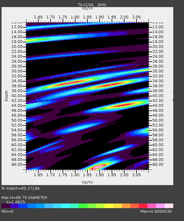
| Estimated Moho Depth: |
68.75 km |
| Estimated Crust Vp/Vs: |
1.89 |
| Assumed Crust Vp: |
6.279 km/s |
| Estimated Crust Vs: |
3.318 km/s |
| Estimated Crust Poisson's Ratio: |
0.31 |
|
| Radial Match: |
95.37166 % |
| Radial Bump: |
400 |
| Transverse Match: |
87.761314 % |
| Transverse Bump: |
400 |
| SOD ConfigId: |
2564 |
| Insert Time: |
2010-03-06 08:47:26.790 +0000 |
| GWidth: |
2.5 |
| Max Bumps: |
400 |
| Tol: |
0.001 |
|
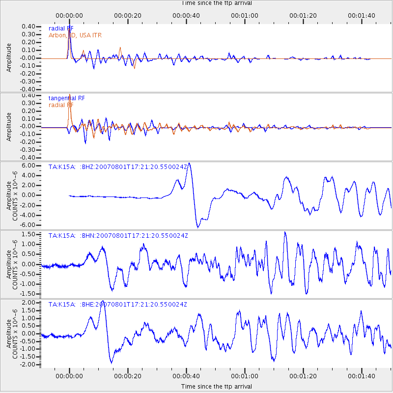
Signal To Noise
| Channel | StoN | STA | LTA |
| TA:K15A: :BHN:20070801T17:21:20.550024Z | 0.74306464 | 4.2592156E-8 | 5.731958E-8 |
| TA:K15A: :BHE:20070801T17:21:20.550024Z | 1.3679738 | 9.3834E-8 | 6.8593415E-8 |
| TA:K15A: :BHZ:20070801T17:21:20.550024Z | 2.6587257 | 2.996216E-7 | 1.1269368E-7 |
| Arrivals |
| Ps | 10.0 SECOND |
| PpPs | 31 SECOND |
| PsPs/PpSs | 41 SECOND |


