You are here: Home > Network List > TA - USArray Transportable Network (new EarthScope stations) Stations List
> Station K15A Arbon, ID, USA > Earthquake Result Viewer
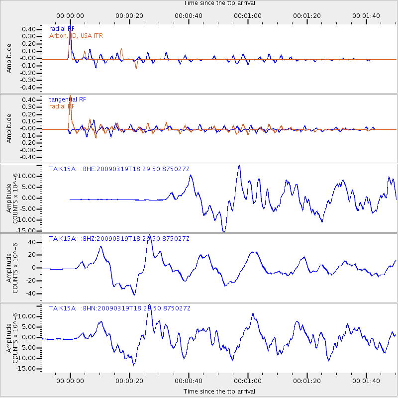
K15A Arbon, ID, USA - Earthquake Result Viewer
| Earthquake location: |
Tonga Islands Region |
| Earthquake latitude/longitude: |
-23.0/-174.7 |
| Earthquake time(UTC): |
2009/03/19 (078) 18:17:40 GMT |
| Earthquake Depth: |
34 km |
| Earthquake Magnitude: |
7.0 MB, 7.6 MS, 7.6 MW, 7.6 MW |
| Earthquake Catalog/Contributor: |
WHDF/NEIC |
|
| Network: |
TA USArray Transportable Network (new EarthScope stations) |
| Station: |
K15A Arbon, ID, USA |
| Lat/Lon: |
42.69 N/112.53 W |
| Elevation: |
1566 m |
|
| Distance: |
86.9 deg |
| Az: |
40.753 deg |
| Baz: |
234.636 deg |
| Ray Param: |
0.043690782 |
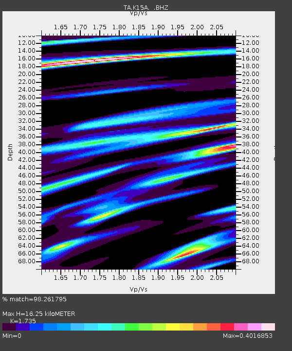
| Estimated Moho Depth: |
16.25 km |
| Estimated Crust Vp/Vs: |
1.74 |
| Assumed Crust Vp: |
6.279 km/s |
| Estimated Crust Vs: |
3.619 km/s |
| Estimated Crust Poisson's Ratio: |
0.25 |
|
| Radial Match: |
98.261795 % |
| Radial Bump: |
351 |
| Transverse Match: |
82.2605 % |
| Transverse Bump: |
400 |
| SOD ConfigId: |
2658 |
| Insert Time: |
2010-03-06 08:47:36.373 +0000 |
| GWidth: |
2.5 |
| Max Bumps: |
400 |
| Tol: |
0.001 |
|
Signal To Noise
| Channel | StoN | STA | LTA |
| TA:K15A: :BHZ:20090319T18:29:50.875027Z | 13.122893 | 4.815586E-6 | 3.669607E-7 |
| TA:K15A: :BHN:20090319T18:29:50.875027Z | 7.1792316 | 1.1734195E-6 | 1.6344639E-7 |
| TA:K15A: :BHE:20090319T18:29:50.875027Z | 9.640664 | 1.2984856E-6 | 1.3468839E-7 |
| Arrivals |
| Ps | 1.9 SECOND |
| PpPs | 6.9 SECOND |
| PsPs/PpSs | 8.9 SECOND |


