You are here: Home > Network List > TA - USArray Transportable Network (new EarthScope stations) Stations List
> Station K15A Arbon, ID, USA > Earthquake Result Viewer
K15A Arbon, ID, USA - Earthquake Result Viewer
| Earthquake location: |
Kuril Islands |
| Earthquake latitude/longitude: |
50.8/155.0 |
| Earthquake time(UTC): |
2009/04/21 (111) 05:26:11 GMT |
| Earthquake Depth: |
152 km |
| Earthquake Magnitude: |
6.0 MB, 6.2 MW, 6.2 MW |
| Earthquake Catalog/Contributor: |
WHDF/NEIC |
|
| Network: |
TA USArray Transportable Network (new EarthScope stations) |
| Station: |
K15A Arbon, ID, USA |
| Lat/Lon: |
42.69 N/112.53 W |
| Elevation: |
1566 m |
|
| Distance: |
59.9 deg |
| Az: |
58.421 deg |
| Baz: |
312.89 deg |
| Ray Param: |
0.06144779 |
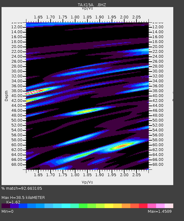
| Estimated Moho Depth: |
38.5 km |
| Estimated Crust Vp/Vs: |
1.62 |
| Assumed Crust Vp: |
6.279 km/s |
| Estimated Crust Vs: |
3.876 km/s |
| Estimated Crust Poisson's Ratio: |
0.19 |
|
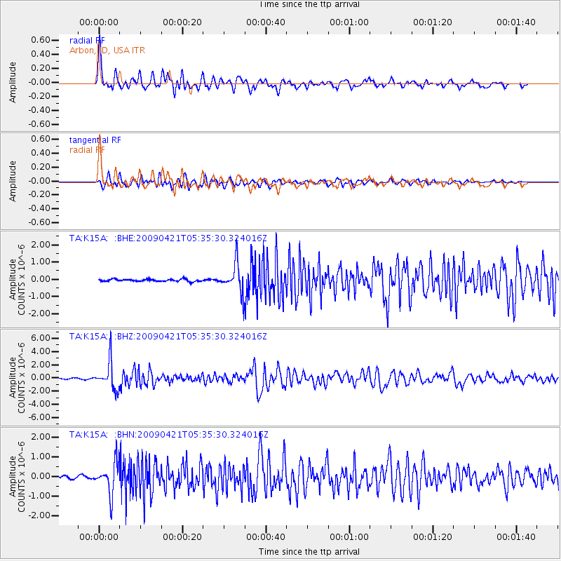
| Radial Match: |
92.663185 % |
| Radial Bump: |
400 |
| Transverse Match: |
82.76776 % |
| Transverse Bump: |
400 |
| SOD ConfigId: |
2760 |
| Insert Time: |
2010-03-06 08:47:54.831 +0000 |
| GWidth: |
2.5 |
| Max Bumps: |
400 |
| Tol: |
0.001 |
|
Signal To Noise
| Channel | StoN | STA | LTA |
| TA:K15A: :BHZ:20090421T05:35:30.324016Z | 32.896988 | 2.191554E-6 | 6.661869E-8 |
| TA:K15A: :BHN:20090421T05:35:30.324016Z | 9.543477 | 8.287467E-7 | 8.683907E-8 |
| TA:K15A: :BHE:20090421T05:35:30.324016Z | 13.656773 | 8.6722343E-7 | 6.3501346E-8 |
| Arrivals |
| Ps | 4.0 SECOND |
| PpPs | 15 SECOND |
| PsPs/PpSs | 19 SECOND |


