You are here: Home > Network List > TA - USArray Transportable Network (new EarthScope stations) Stations List
> Station K15A Arbon, ID, USA > Earthquake Result Viewer
K15A Arbon, ID, USA - Earthquake Result Viewer
| Earthquake location: |
Loyalty Islands |
| Earthquake latitude/longitude: |
-20.1/168.9 |
| Earthquake time(UTC): |
2008/04/09 (100) 12:46:12 GMT |
| Earthquake Depth: |
33 km |
| Earthquake Magnitude: |
6.3 MB, 7.3 MS, 7.3 MW, 7.3 MW |
| Earthquake Catalog/Contributor: |
WHDF/NEIC |
|
| Network: |
TA USArray Transportable Network (new EarthScope stations) |
| Station: |
K15A Arbon, ID, USA |
| Lat/Lon: |
42.69 N/112.53 W |
| Elevation: |
1566 m |
|
| Distance: |
95.3 deg |
| Az: |
46.544 deg |
| Baz: |
247.731 deg |
| Ray Param: |
0.040792078 |
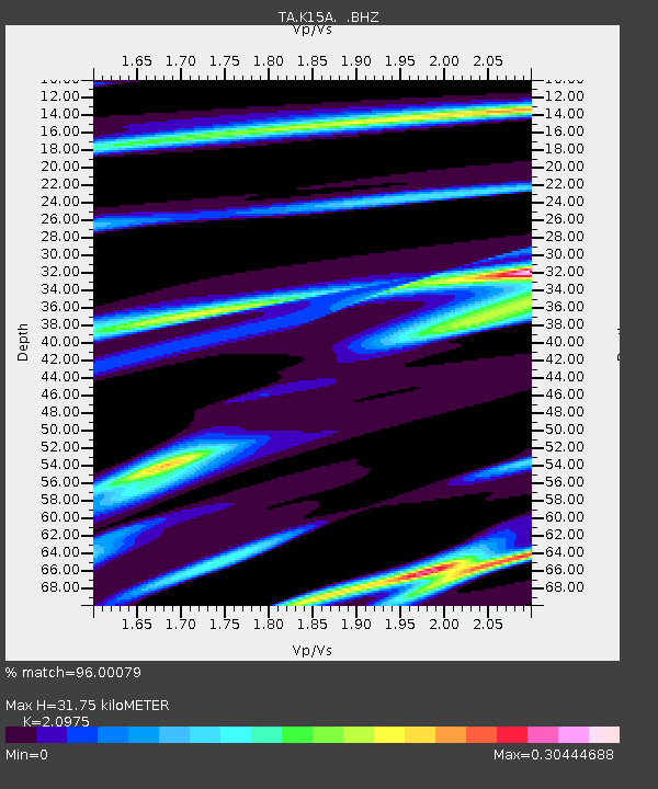
| Estimated Moho Depth: |
31.75 km |
| Estimated Crust Vp/Vs: |
2.10 |
| Assumed Crust Vp: |
6.279 km/s |
| Estimated Crust Vs: |
2.993 km/s |
| Estimated Crust Poisson's Ratio: |
0.35 |
|
| Radial Match: |
96.00079 % |
| Radial Bump: |
253 |
| Transverse Match: |
91.395615 % |
| Transverse Bump: |
386 |
| SOD ConfigId: |
2504 |
| Insert Time: |
2010-03-06 08:47:56.899 +0000 |
| GWidth: |
2.5 |
| Max Bumps: |
400 |
| Tol: |
0.001 |
|
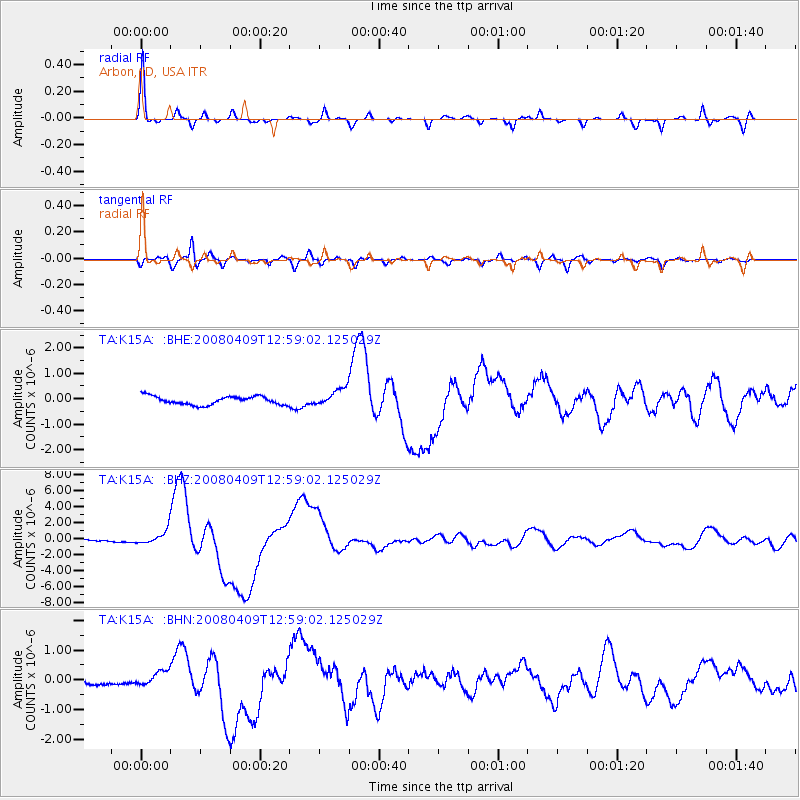
Signal To Noise
| Channel | StoN | STA | LTA |
| TA:K15A: :BHZ:20080409T12:59:02.125029Z | 7.666775 | 8.750451E-7 | 1.141347E-7 |
| TA:K15A: :BHN:20080409T12:59:02.125029Z | 1.6296767 | 2.473584E-7 | 1.5178374E-7 |
| TA:K15A: :BHE:20080409T12:59:02.125029Z | 2.0374882 | 3.3732735E-7 | 1.655604E-7 |
| Arrivals |
| Ps | 5.6 SECOND |
| PpPs | 15 SECOND |
| PsPs/PpSs | 21 SECOND |


