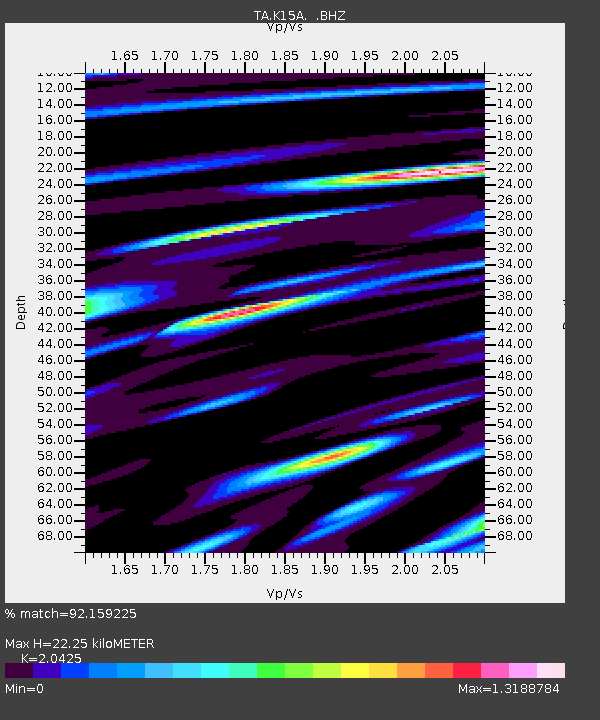
K15A Arbon, ID, USA - Earthquake Result Viewer
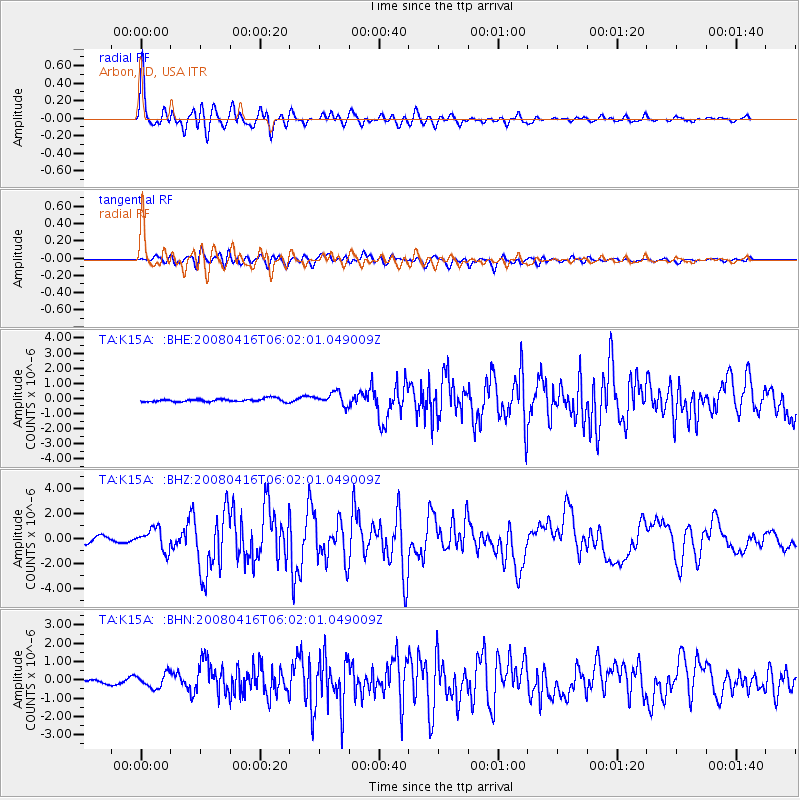
Earthquake location: Andreanof Islands, Aleutian Is.
Earthquake latitude/longitude: 51.9/-179.2
Earthquake time(UTC): 2008/04/16 (107) 05:54:19 GMT
Earthquake Depth: 13 km
Earthquake Magnitude: 6.1 MB, 6.5 MS, 6.6 MW, 6.6 MW
Earthquake Catalog/Contributor: WHDF/NEIC
Network: TA USArray Transportable Network (new EarthScope stations)
Station: K15A Arbon, ID, USA
Lat/Lon: 42.69 N/112.53 W
Elevation: 1566 m
Distance: 44.7 deg
Az: 74.377 deg
Baz: 305.938 deg
Ray Param: 0.07177447
Estimated Moho Depth: 22.25 km
Estimated Crust Vp/Vs: 2.04
Assumed Crust Vp: 6.279 km/s
Estimated Crust Vs: 3.074 km/s
Estimated Crust Poisson's Ratio: 0.34
Radial Match: 92.159225 %
Radial Bump: 400
Transverse Match: 81.29956 %
Transverse Bump: 400
SOD ConfigId: 2504
Insert Time: 2010-03-06 08:48:00.448 +0000
GWidth: 2.5
Max Bumps: 400
Tol: 0.001

Signal To Noise

ChannelStoNSTALTA
TA:K15A: :BHZ:20080416T06:02:01.049009Z3.94306648.728478E-72.213627E-7
TA:K15A: :BHN:20080416T06:02:01.049009Z2.34452223.7652927E-71.6059958E-7
TA:K15A: :BHE:20080416T06:02:01.049009Z4.0915364.234551E-71.0349538E-7
Arrivals
Ps3.9 SECOND
PpPs10 SECOND
PsPs/PpSs14 SECOND