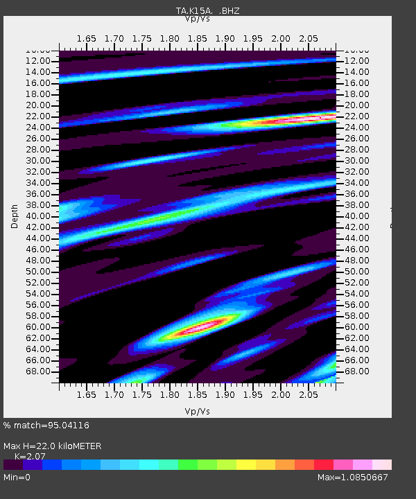
K15A Arbon, ID, USA - Earthquake Result Viewer
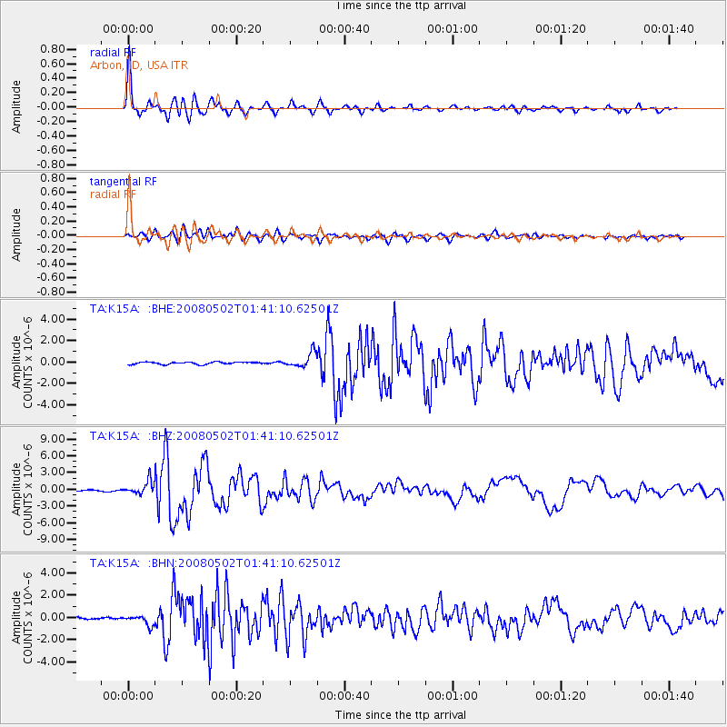
Earthquake location: Andreanof Islands, Aleutian Is.
Earthquake latitude/longitude: 51.9/-177.5
Earthquake time(UTC): 2008/05/02 (123) 01:33:37 GMT
Earthquake Depth: 14 km
Earthquake Magnitude: 6.3 MB, 6.8 MS, 6.6 MW, 6.6 MW
Earthquake Catalog/Contributor: WHDF/NEIC
Network: TA USArray Transportable Network (new EarthScope stations)
Station: K15A Arbon, ID, USA
Lat/Lon: 42.69 N/112.53 W
Elevation: 1566 m
Distance: 43.7 deg
Az: 75.375 deg
Baz: 305.539 deg
Ray Param: 0.07238429
Estimated Moho Depth: 22.0 km
Estimated Crust Vp/Vs: 2.07
Assumed Crust Vp: 6.279 km/s
Estimated Crust Vs: 3.033 km/s
Estimated Crust Poisson's Ratio: 0.35
Radial Match: 95.04116 %
Radial Bump: 372
Transverse Match: 82.18429 %
Transverse Bump: 400
SOD ConfigId: 2504
Insert Time: 2010-03-06 08:48:02.706 +0000
GWidth: 2.5
Max Bumps: 400
Tol: 0.001

Signal To Noise

ChannelStoNSTALTA
TA:K15A: :BHZ:20080502T01:41:10.62501Z7.05101541.221476E-61.7323406E-7
TA:K15A: :BHN:20080502T01:41:10.62501Z2.5207834.4118252E-71.7501806E-7
TA:K15A: :BHE:20080502T01:41:10.62501Z6.64191347.019353E-71.05682695E-7
Arrivals
Ps4.0 SECOND
PpPs10 SECOND
PsPs/PpSs14 SECOND