You are here: Home > Network List > UU - University of Utah Regional Network Stations List
> Station HVU Hansel Valley, UT, USA > Earthquake Result Viewer
HVU Hansel Valley, UT, USA - Earthquake Result Viewer

| Earthquake location: |
Near Coast Of Ecuador |
| Earthquake latitude/longitude: |
0.6/-80.3 |
| Earthquake time(UTC): |
2016/04/20 (111) 08:33:48 GMT |
| Earthquake Depth: |
16 km |
| Earthquake Magnitude: |
6.1 MO |
| Earthquake Catalog/Contributor: |
NEIC PDE/NEIC ALERT |
|
| Network: |
UU University of Utah Regional Network |
| Station: |
HVU Hansel Valley, UT, USA |
| Lat/Lon: |
41.78 N/112.78 W |
| Elevation: |
1609 m |
|
| Distance: |
50.4 deg |
| Az: |
328.542 deg |
| Baz: |
135.756 deg |
| Ray Param: |
0.068078466 |
| Estimated Moho Depth: |
25.75 km |
| Estimated Crust Vp/Vs: |
2.03 |
| Assumed Crust Vp: |
6.276 km/s |
| Estimated Crust Vs: |
3.092 km/s |
| Estimated Crust Poisson's Ratio: |
0.34 |
|
| Radial Match: |
86.59517 % |
| Radial Bump: |
350 |
| Transverse Match: |
67.34535 % |
| Transverse Bump: |
386 |
| SOD ConfigId: |
1475611 |
| Insert Time: |
2016-05-04 08:55:33.749 +0000 |
| GWidth: |
2.5 |
| Max Bumps: |
400 |
| Tol: |
0.001 |
|
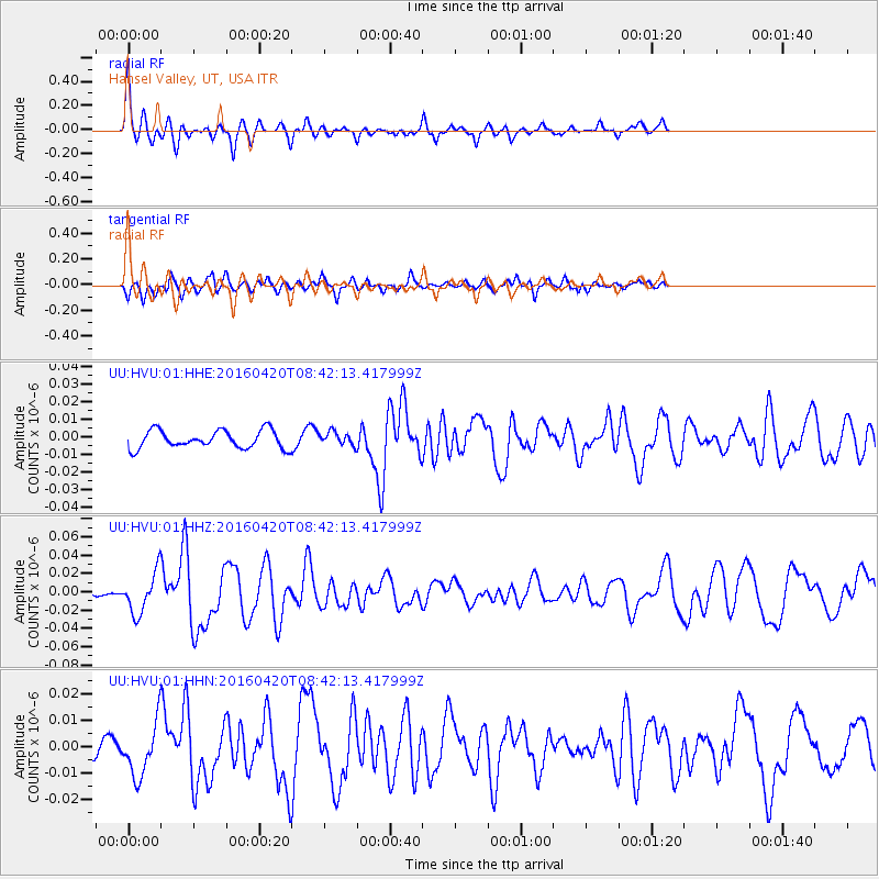
Signal To Noise
| Channel | StoN | STA | LTA |
| UU:HVU:01:HHZ:20160420T08:42:13.417999Z | 3.8319314 | 2.15622E-8 | 5.6269793E-9 |
| UU:HVU:01:HHN:20160420T08:42:13.417999Z | 1.7866751 | 9.665144E-9 | 5.4095706E-9 |
| UU:HVU:01:HHE:20160420T08:42:13.417999Z | 0.7195038 | 3.652479E-9 | 5.076386E-9 |
| Arrivals |
| Ps | 4.4 SECOND |
| PpPs | 12 SECOND |
| PsPs/PpSs | 16 SECOND |


