You are here: Home > Network List > WY - Yellowstone Wyoming Seismic Network Stations List
> Station YHH Holmes Hill, YNP, WY, USA > Earthquake Result Viewer
YHH Holmes Hill, YNP, WY, USA - Earthquake Result Viewer
| Earthquake location: |
Near Coast Of Ecuador |
| Earthquake latitude/longitude: |
0.6/-80.3 |
| Earthquake time(UTC): |
2016/04/20 (111) 08:33:48 GMT |
| Earthquake Depth: |
16 km |
| Earthquake Magnitude: |
6.1 MO |
| Earthquake Catalog/Contributor: |
NEIC PDE/NEIC ALERT |
|
| Network: |
WY Yellowstone Wyoming Seismic Network |
| Station: |
YHH Holmes Hill, YNP, WY, USA |
| Lat/Lon: |
44.79 N/110.85 W |
| Elevation: |
2717 m |
|
| Distance: |
51.7 deg |
| Az: |
332.484 deg |
| Baz: |
139.551 deg |
| Ray Param: |
0.06725378 |
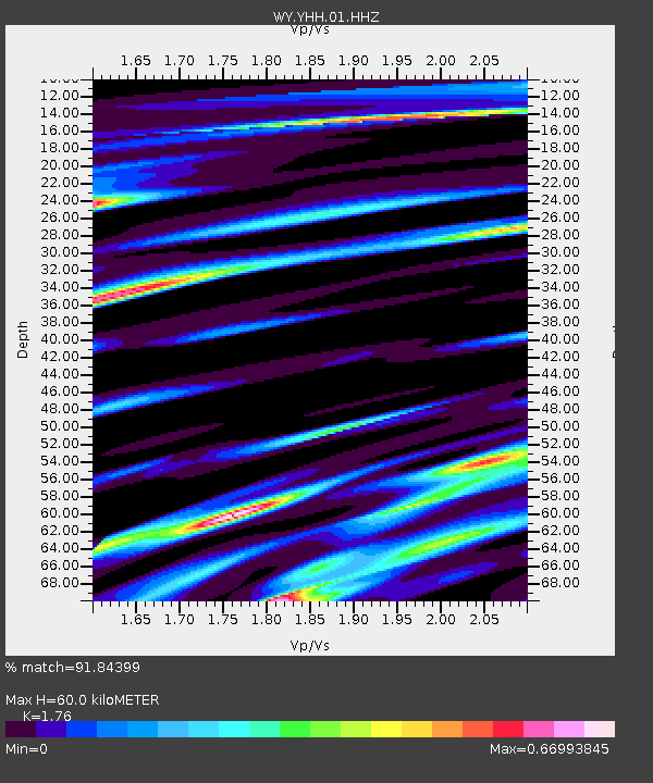
| Estimated Moho Depth: |
60.0 km |
| Estimated Crust Vp/Vs: |
1.76 |
| Assumed Crust Vp: |
6.35 km/s |
| Estimated Crust Vs: |
3.608 km/s |
| Estimated Crust Poisson's Ratio: |
0.26 |
|
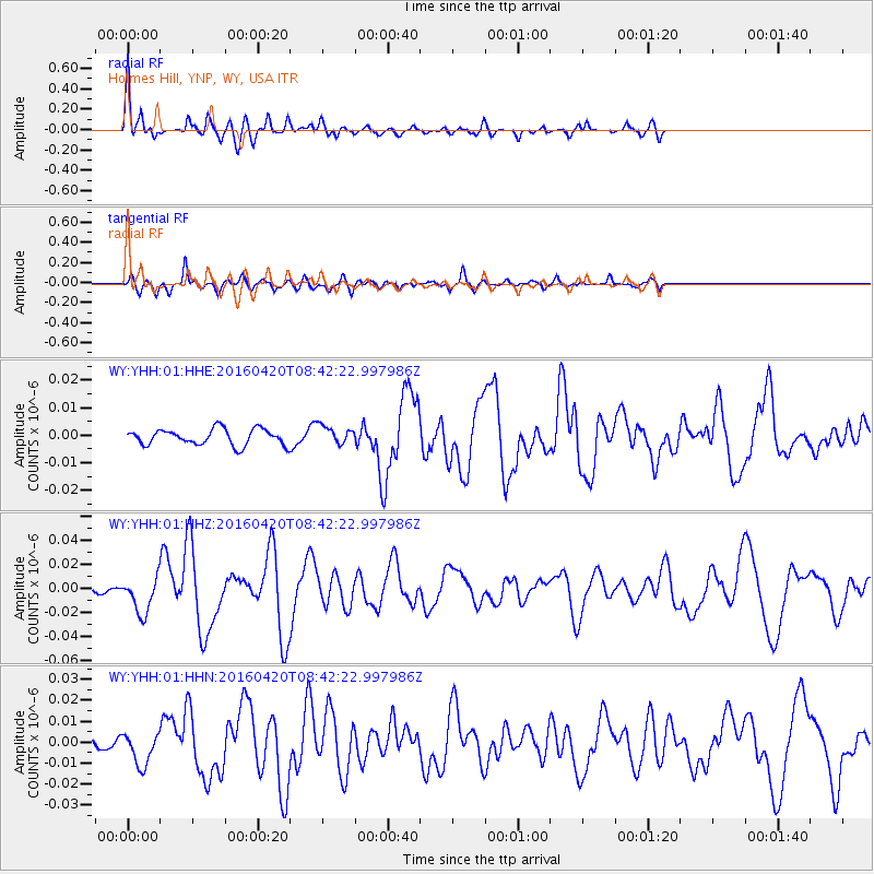
| Radial Match: |
91.84399 % |
| Radial Bump: |
400 |
| Transverse Match: |
77.71888 % |
| Transverse Bump: |
400 |
| SOD ConfigId: |
1475611 |
| Insert Time: |
2016-05-04 08:58:01.572 +0000 |
| GWidth: |
2.5 |
| Max Bumps: |
400 |
| Tol: |
0.001 |
|
Signal To Noise
| Channel | StoN | STA | LTA |
| WY:YHH:01:HHZ:20160420T08:42:22.997986Z | 5.4918175 | 1.4987814E-8 | 2.7291172E-9 |
| WY:YHH:01:HHN:20160420T08:42:22.997986Z | 2.9512095 | 7.827384E-9 | 2.652263E-9 |
| WY:YHH:01:HHE:20160420T08:42:22.997986Z | 1.1516879 | 3.327672E-9 | 2.889387E-9 |
| Arrivals |
| Ps | 7.6 SECOND |
| PpPs | 25 SECOND |
| PsPs/PpSs | 32 SECOND |


