You are here: Home > Network List > WY - Yellowstone Wyoming Seismic Network Stations List
> Station YMR Madison River, YNP, WY, USA > Earthquake Result Viewer
YMR Madison River, YNP, WY, USA - Earthquake Result Viewer
| Earthquake location: |
Near Coast Of Ecuador |
| Earthquake latitude/longitude: |
0.6/-80.3 |
| Earthquake time(UTC): |
2016/04/20 (111) 08:33:48 GMT |
| Earthquake Depth: |
16 km |
| Earthquake Magnitude: |
6.1 MO |
| Earthquake Catalog/Contributor: |
NEIC PDE/NEIC ALERT |
|
| Network: |
WY Yellowstone Wyoming Seismic Network |
| Station: |
YMR Madison River, YNP, WY, USA |
| Lat/Lon: |
44.67 N/110.96 W |
| Elevation: |
2149 m |
|
| Distance: |
51.6 deg |
| Az: |
332.306 deg |
| Baz: |
139.36 deg |
| Ray Param: |
0.06727896 |
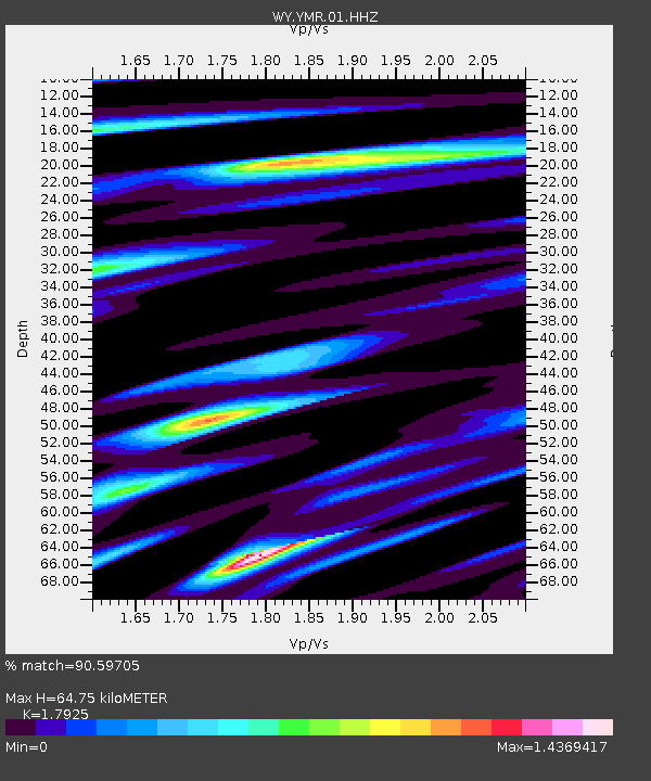
| Estimated Moho Depth: |
64.75 km |
| Estimated Crust Vp/Vs: |
1.79 |
| Assumed Crust Vp: |
6.35 km/s |
| Estimated Crust Vs: |
3.543 km/s |
| Estimated Crust Poisson's Ratio: |
0.27 |
|
| Radial Match: |
90.59705 % |
| Radial Bump: |
400 |
| Transverse Match: |
73.23789 % |
| Transverse Bump: |
400 |
| SOD ConfigId: |
1475611 |
| Insert Time: |
2016-05-04 08:58:27.419 +0000 |
| GWidth: |
2.5 |
| Max Bumps: |
400 |
| Tol: |
0.001 |
|

Signal To Noise
| Channel | StoN | STA | LTA |
| WY:YMR:01:HHZ:20160420T08:42:22.718018Z | 3.8725429 | 1.4584015E-8 | 3.766005E-9 |
| WY:YMR:01:HHN:20160420T08:42:22.718018Z | 2.202933 | 1.1841215E-8 | 5.3752043E-9 |
| WY:YMR:01:HHE:20160420T08:42:22.718018Z | 1.4844517 | 7.800361E-9 | 5.2547087E-9 |
| Arrivals |
| Ps | 8.5 SECOND |
| PpPs | 27 SECOND |
| PsPs/PpSs | 36 SECOND |


