You are here: Home > Network List > WY - Yellowstone Wyoming Seismic Network Stations List
> Station YUF Upper Falls, WY, USA > Earthquake Result Viewer
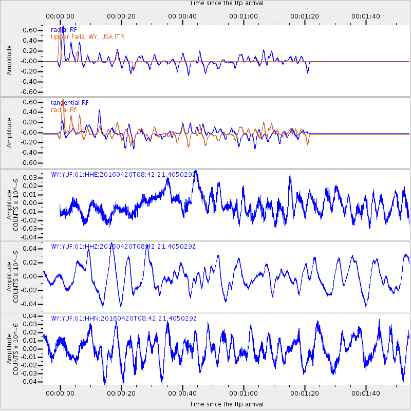
YUF Upper Falls, WY, USA - Earthquake Result Viewer
*The percent match for this event was below the threshold and hence no stack was calculated.
| Earthquake location: |
Near Coast Of Ecuador |
| Earthquake latitude/longitude: |
0.6/-80.3 |
| Earthquake time(UTC): |
2016/04/20 (111) 08:33:48 GMT |
| Earthquake Depth: |
16 km |
| Earthquake Magnitude: |
6.1 MO |
| Earthquake Catalog/Contributor: |
NEIC PDE/NEIC ALERT |
|
| Network: |
WY Yellowstone Wyoming Seismic Network |
| Station: |
YUF Upper Falls, WY, USA |
| Lat/Lon: |
44.71 N/110.51 W |
| Elevation: |
2394 m |
|
| Distance: |
51.4 deg |
| Az: |
332.657 deg |
| Baz: |
139.896 deg |
| Ray Param: |
$rayparam |
*The percent match for this event was below the threshold and hence was not used in the summary stack. |
|
| Radial Match: |
74.24016 % |
| Radial Bump: |
400 |
| Transverse Match: |
47.099724 % |
| Transverse Bump: |
400 |
| SOD ConfigId: |
1475611 |
| Insert Time: |
2016-05-04 08:58:54.330 +0000 |
| GWidth: |
2.5 |
| Max Bumps: |
400 |
| Tol: |
0.001 |
|
Signal To Noise
| Channel | StoN | STA | LTA |
| WY:YUF:01:HHZ:20160420T08:42:21.405029Z | 2.94659 | 1.0824836E-8 | 3.6736825E-9 |
| WY:YUF:01:HHN:20160420T08:42:21.405029Z | 1.4169507 | 8.9332355E-9 | 6.3045493E-9 |
| WY:YUF:01:HHE:20160420T08:42:21.405029Z | 2.8525505 | 1.9616746E-8 | 6.876914E-9 |
| Arrivals |
| Ps | |
| PpPs | |
| PsPs/PpSs | |


