You are here: Home > Network List > CO - South Carolina Seismic Network Stations List
> Station PAULI CO:PAULI > Earthquake Result Viewer
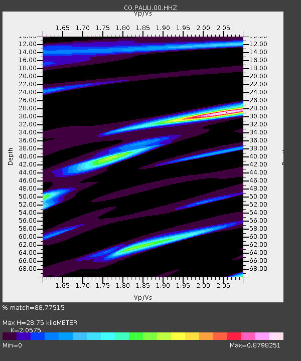
PAULI CO:PAULI - Earthquake Result Viewer
| Earthquake location: |
Near Coast Of Ecuador |
| Earthquake latitude/longitude: |
0.7/-80.0 |
| Earthquake time(UTC): |
2016/04/20 (111) 08:35:10 GMT |
| Earthquake Depth: |
10 km |
| Earthquake Magnitude: |
6.0 MWB |
| Earthquake Catalog/Contributor: |
NEIC PDE/NEIC COMCAT |
|
| Network: |
CO South Carolina Seismic Network |
| Station: |
PAULI CO:PAULI |
| Lat/Lon: |
34.82 N/81.81 W |
| Elevation: |
179 m |
|
| Distance: |
34.0 deg |
| Az: |
357.342 deg |
| Baz: |
176.769 deg |
| Ray Param: |
0.07795895 |
| Estimated Moho Depth: |
28.75 km |
| Estimated Crust Vp/Vs: |
2.06 |
| Assumed Crust Vp: |
6.419 km/s |
| Estimated Crust Vs: |
3.12 km/s |
| Estimated Crust Poisson's Ratio: |
0.35 |
|
| Radial Match: |
88.77515 % |
| Radial Bump: |
306 |
| Transverse Match: |
56.40462 % |
| Transverse Bump: |
400 |
| SOD ConfigId: |
1475611 |
| Insert Time: |
2016-05-04 09:00:52.248 +0000 |
| GWidth: |
2.5 |
| Max Bumps: |
400 |
| Tol: |
0.001 |
|

Signal To Noise
| Channel | StoN | STA | LTA |
| CO:PAULI:00:HHZ:20160420T08:41:23.589995Z | 2.5903804 | 1.5593608E-6 | 6.019814E-7 |
| CO:PAULI:00:HHN:20160420T08:41:23.589995Z | 2.6635725 | 9.7672E-7 | 3.6669545E-7 |
| CO:PAULI:00:HHE:20160420T08:41:23.589995Z | 1.0996763 | 1.7129241E-7 | 1.5576623E-7 |
| Arrivals |
| Ps | 5.1 SECOND |
| PpPs | 13 SECOND |
| PsPs/PpSs | 18 SECOND |


