You are here: Home > Network List > GS - US Geological Survey Networks Stations List
> Station KAN10 Keim Farm > Earthquake Result Viewer
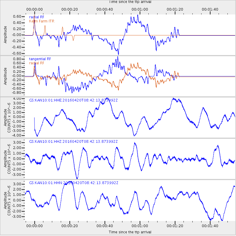
KAN10 Keim Farm - Earthquake Result Viewer
*The percent match for this event was below the threshold and hence no stack was calculated.
| Earthquake location: |
Near Coast Of Ecuador |
| Earthquake latitude/longitude: |
0.7/-80.0 |
| Earthquake time(UTC): |
2016/04/20 (111) 08:35:10 GMT |
| Earthquake Depth: |
10 km |
| Earthquake Magnitude: |
6.0 MWB |
| Earthquake Catalog/Contributor: |
NEIC PDE/NEIC COMCAT |
|
| Network: |
GS US Geological Survey Networks |
| Station: |
KAN10 Keim Farm |
| Lat/Lon: |
37.12 N/98.10 W |
| Elevation: |
417 m |
|
| Distance: |
39.9 deg |
| Az: |
337.245 deg |
| Baz: |
151.06 deg |
| Ray Param: |
$rayparam |
*The percent match for this event was below the threshold and hence was not used in the summary stack. |
|
| Radial Match: |
34.727493 % |
| Radial Bump: |
400 |
| Transverse Match: |
37.440033 % |
| Transverse Bump: |
400 |
| SOD ConfigId: |
1475611 |
| Insert Time: |
2016-05-04 09:02:39.386 +0000 |
| GWidth: |
2.5 |
| Max Bumps: |
400 |
| Tol: |
0.001 |
|
Signal To Noise
| Channel | StoN | STA | LTA |
| GS:KAN10:01:HHZ:20160420T08:42:13.873992Z | 0.94115907 | 5.743156E-7 | 6.102216E-7 |
| GS:KAN10:01:HHN:20160420T08:42:13.873992Z | 0.5621609 | 6.899181E-7 | 1.2272609E-6 |
| GS:KAN10:01:HHE:20160420T08:42:13.873992Z | 1.1499953 | 1.6500943E-6 | 1.4348705E-6 |
| Arrivals |
| Ps | |
| PpPs | |
| PsPs/PpSs | |


