You are here: Home > Network List > TA - USArray Transportable Network (new EarthScope stations) Stations List
> Station D25K Kavik River, AK, USA > Earthquake Result Viewer
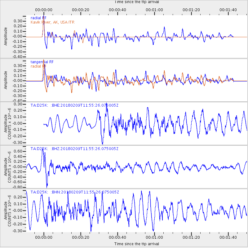
D25K Kavik River, AK, USA - Earthquake Result Viewer
*The percent match for this event was below the threshold and hence no stack was calculated.
| Earthquake location: |
Fiji Islands Region |
| Earthquake latitude/longitude: |
-17.9/-178.7 |
| Earthquake time(UTC): |
2018/02/09 (040) 11:43:56 GMT |
| Earthquake Depth: |
545 km |
| Earthquake Magnitude: |
5.9 Mww |
| Earthquake Catalog/Contributor: |
NEIC PDE/us |
|
| Network: |
TA USArray Transportable Network (new EarthScope stations) |
| Station: |
D25K Kavik River, AK, USA |
| Lat/Lon: |
69.32 N/146.38 W |
| Elevation: |
770 m |
|
| Distance: |
90.0 deg |
| Az: |
10.938 deg |
| Baz: |
210.576 deg |
| Ray Param: |
$rayparam |
*The percent match for this event was below the threshold and hence was not used in the summary stack. |
|
| Radial Match: |
66.207985 % |
| Radial Bump: |
400 |
| Transverse Match: |
66.420654 % |
| Transverse Bump: |
400 |
| SOD ConfigId: |
13570011 |
| Insert Time: |
2019-04-29 18:39:52.449 +0000 |
| GWidth: |
2.5 |
| Max Bumps: |
400 |
| Tol: |
0.001 |
|
Signal To Noise
| Channel | StoN | STA | LTA |
| TA:D25K: :BHZ:20180209T11:55:26.075005Z | 3.6351304 | 4.0715554E-7 | 1.1200576E-7 |
| TA:D25K: :BHN:20180209T11:55:26.075005Z | 1.0847603 | 1.3350639E-7 | 1.2307454E-7 |
| TA:D25K: :BHE:20180209T11:55:26.075005Z | 2.5988784 | 1.8904866E-7 | 7.27424E-8 |
| Arrivals |
| Ps | |
| PpPs | |
| PsPs/PpSs | |


