You are here: Home > Network List > TA - USArray Transportable Network (new EarthScope stations) Stations List
> Station X14A Yava, AZ, USA > Earthquake Result Viewer
X14A Yava, AZ, USA - Earthquake Result Viewer

| Earthquake location: |
Kuril Islands |
| Earthquake latitude/longitude: |
51.0/157.6 |
| Earthquake time(UTC): |
2008/07/24 (206) 01:43:16 GMT |
| Earthquake Depth: |
27 km |
| Earthquake Magnitude: |
6.0 MB, 6.0 MS, 6.2 MW, 6.2 MW |
| Earthquake Catalog/Contributor: |
WHDF/NEIC |
|
| Network: |
TA USArray Transportable Network (new EarthScope stations) |
| Station: |
X14A Yava, AZ, USA |
| Lat/Lon: |
34.47 N/112.89 W |
| Elevation: |
1078 m |
|
| Distance: |
63.8 deg |
| Az: |
66.986 deg |
| Baz: |
315.217 deg |
| Ray Param: |
0.059270818 |
| Estimated Moho Depth: |
32.0 km |
| Estimated Crust Vp/Vs: |
1.73 |
| Assumed Crust Vp: |
6.276 km/s |
| Estimated Crust Vs: |
3.628 km/s |
| Estimated Crust Poisson's Ratio: |
0.25 |
|
| Radial Match: |
91.36644 % |
| Radial Bump: |
261 |
| Transverse Match: |
70.08438 % |
| Transverse Bump: |
389 |
| SOD ConfigId: |
2504 |
| Insert Time: |
2010-03-06 08:50:43.903 +0000 |
| GWidth: |
2.5 |
| Max Bumps: |
400 |
| Tol: |
0.001 |
|
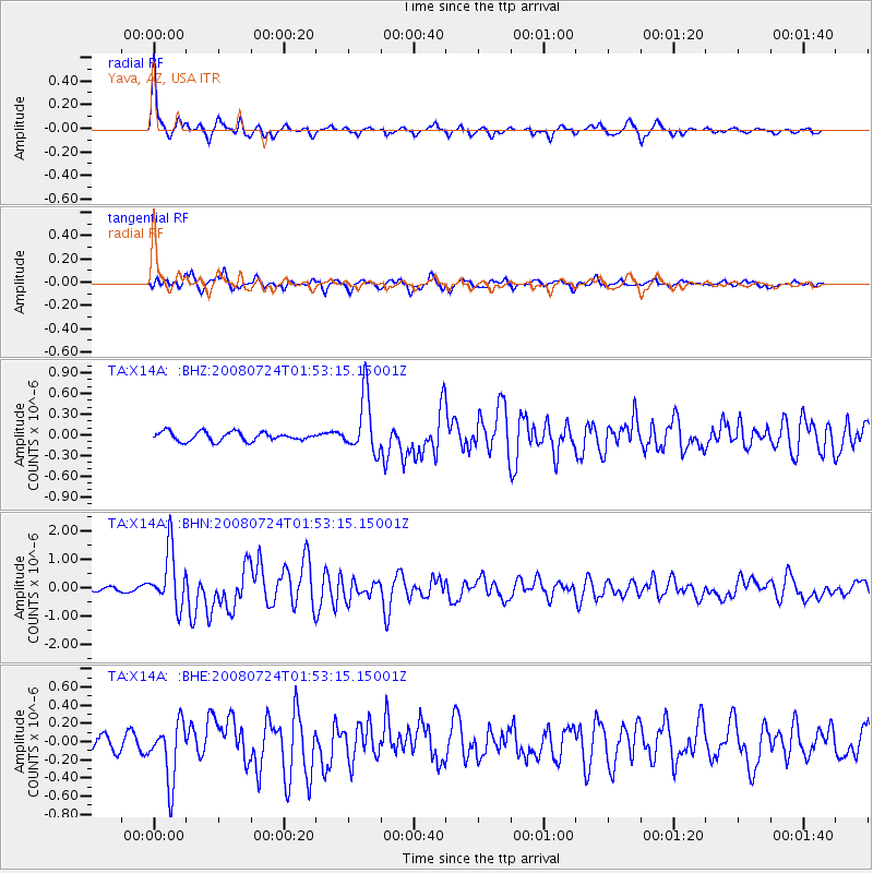
Signal To Noise
| Channel | StoN | STA | LTA |
| TA:X14A: :BHN:20080724T01:53:15.15001Z | 8.853232 | 9.877862E-7 | 1.115735E-7 |
| TA:X14A: :BHE:20080724T01:53:15.15001Z | 2.869803 | 3.2020017E-7 | 1.11575666E-7 |
| TA:X14A: :BHZ:20080724T01:53:15.15001Z | 6.3856826 | 4.1432222E-7 | 6.4883E-8 |
| Arrivals |
| Ps | 3.9 SECOND |
| PpPs | 13 SECOND |
| PsPs/PpSs | 17 SECOND |


