You are here: Home > Network List > TA - USArray Transportable Network (new EarthScope stations) Stations List
> Station X14A Yava, AZ, USA > Earthquake Result Viewer
X14A Yava, AZ, USA - Earthquake Result Viewer
| Earthquake location: |
Tonga Islands |
| Earthquake latitude/longitude: |
-15.1/-173.5 |
| Earthquake time(UTC): |
2008/08/19 (232) 16:30:13 GMT |
| Earthquake Depth: |
8.0 km |
| Earthquake Magnitude: |
5.6 MB, 5.9 MS, 6.1 MW, 6.0 MW |
| Earthquake Catalog/Contributor: |
WHDF/NEIC |
|
| Network: |
TA USArray Transportable Network (new EarthScope stations) |
| Station: |
X14A Yava, AZ, USA |
| Lat/Lon: |
34.47 N/112.89 W |
| Elevation: |
1078 m |
|
| Distance: |
75.7 deg |
| Az: |
47.95 deg |
| Baz: |
240.247 deg |
| Ray Param: |
0.051465333 |
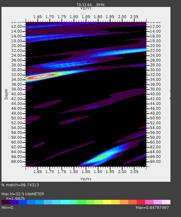
| Estimated Moho Depth: |
32.5 km |
| Estimated Crust Vp/Vs: |
1.66 |
| Assumed Crust Vp: |
6.276 km/s |
| Estimated Crust Vs: |
3.775 km/s |
| Estimated Crust Poisson's Ratio: |
0.22 |
|
| Radial Match: |
86.74313 % |
| Radial Bump: |
395 |
| Transverse Match: |
71.83873 % |
| Transverse Bump: |
400 |
| SOD ConfigId: |
2504 |
| Insert Time: |
2010-03-06 08:50:47.694 +0000 |
| GWidth: |
2.5 |
| Max Bumps: |
400 |
| Tol: |
0.001 |
|

Signal To Noise
| Channel | StoN | STA | LTA |
| TA:X14A: :BHN:20080819T16:41:27.949014Z | 10.91578 | 5.482376E-7 | 5.0224315E-8 |
| TA:X14A: :BHE:20080819T16:41:27.949014Z | 2.378388 | 1.2455622E-7 | 5.2370023E-8 |
| TA:X14A: :BHZ:20080819T16:41:27.949014Z | 4.2953696 | 1.9958964E-7 | 4.6466234E-8 |
| Arrivals |
| Ps | 3.5 SECOND |
| PpPs | 13 SECOND |
| PsPs/PpSs | 17 SECOND |


