You are here: Home > Network List > GS - US Geological Survey Networks Stations List
> Station OK030 Cody Creek RV Park, Cushing, OK, USA > Earthquake Result Viewer
OK030 Cody Creek RV Park, Cushing, OK, USA - Earthquake Result Viewer
| Earthquake location: |
Near Coast Of Ecuador |
| Earthquake latitude/longitude: |
0.7/-80.0 |
| Earthquake time(UTC): |
2016/04/20 (111) 08:35:10 GMT |
| Earthquake Depth: |
10 km |
| Earthquake Magnitude: |
6.0 MWB |
| Earthquake Catalog/Contributor: |
NEIC PDE/NEIC COMCAT |
|
| Network: |
GS US Geological Survey Networks |
| Station: |
OK030 Cody Creek RV Park, Cushing, OK, USA |
| Lat/Lon: |
35.93 N/96.78 W |
| Elevation: |
289 m |
|
| Distance: |
38.4 deg |
| Az: |
337.821 deg |
| Baz: |
152.284 deg |
| Ray Param: |
0.07561159 |
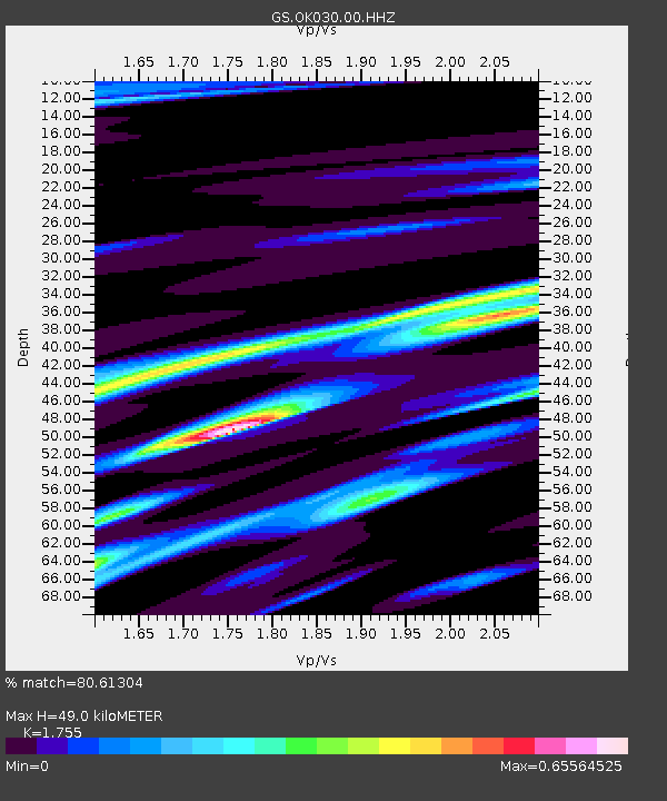
| Estimated Moho Depth: |
49.0 km |
| Estimated Crust Vp/Vs: |
1.75 |
| Assumed Crust Vp: |
6.426 km/s |
| Estimated Crust Vs: |
3.662 km/s |
| Estimated Crust Poisson's Ratio: |
0.26 |
|
| Radial Match: |
80.61304 % |
| Radial Bump: |
355 |
| Transverse Match: |
59.82387 % |
| Transverse Bump: |
400 |
| SOD ConfigId: |
1475611 |
| Insert Time: |
2016-05-04 09:03:17.516 +0000 |
| GWidth: |
2.5 |
| Max Bumps: |
400 |
| Tol: |
0.001 |
|

Signal To Noise
| Channel | StoN | STA | LTA |
| GS:OK030:00:HHZ:20160420T08:42:00.919005Z | 1.957272 | 8.7036375E-7 | 4.4468203E-7 |
| GS:OK030:00:HH1:20160420T08:42:00.919005Z | 1.2260051 | 4.3444177E-7 | 3.543556E-7 |
| GS:OK030:00:HH2:20160420T08:42:00.919005Z | 1.1649497 | 3.2024707E-7 | 2.7490205E-7 |
| Arrivals |
| Ps | 6.2 SECOND |
| PpPs | 20 SECOND |
| PsPs/PpSs | 26 SECOND |


