You are here: Home > Network List > TA - USArray Transportable Network (new EarthScope stations) Stations List
> Station R31K City Hall, Gustavus, AK, USA > Earthquake Result Viewer
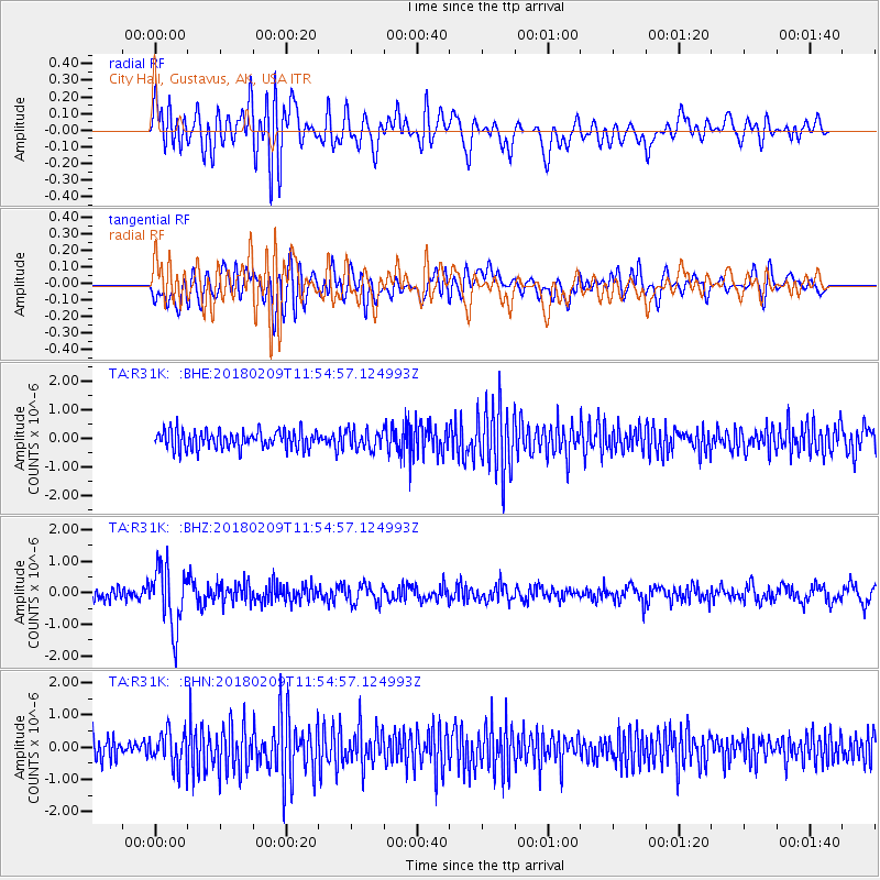
R31K City Hall, Gustavus, AK, USA - Earthquake Result Viewer
*The percent match for this event was below the threshold and hence no stack was calculated.
| Earthquake location: |
Fiji Islands Region |
| Earthquake latitude/longitude: |
-17.9/-178.7 |
| Earthquake time(UTC): |
2018/02/09 (040) 11:43:56 GMT |
| Earthquake Depth: |
545 km |
| Earthquake Magnitude: |
5.9 Mww |
| Earthquake Catalog/Contributor: |
NEIC PDE/us |
|
| Network: |
TA USArray Transportable Network (new EarthScope stations) |
| Station: |
R31K City Hall, Gustavus, AK, USA |
| Lat/Lon: |
58.41 N/135.74 W |
| Elevation: |
15 m |
|
| Distance: |
83.8 deg |
| Az: |
21.134 deg |
| Baz: |
220.715 deg |
| Ray Param: |
$rayparam |
*The percent match for this event was below the threshold and hence was not used in the summary stack. |
|
| Radial Match: |
53.377422 % |
| Radial Bump: |
400 |
| Transverse Match: |
50.13289 % |
| Transverse Bump: |
400 |
| SOD ConfigId: |
13570011 |
| Insert Time: |
2019-04-29 18:41:26.896 +0000 |
| GWidth: |
2.5 |
| Max Bumps: |
400 |
| Tol: |
0.001 |
|
Signal To Noise
| Channel | StoN | STA | LTA |
| TA:R31K: :BHZ:20180209T11:54:57.124993Z | 4.326316 | 9.4285275E-7 | 2.1793433E-7 |
| TA:R31K: :BHN:20180209T11:54:57.124993Z | 1.466095 | 5.3133584E-7 | 3.6241568E-7 |
| TA:R31K: :BHE:20180209T11:54:57.124993Z | 1.0743517 | 3.3456732E-7 | 3.114132E-7 |
| Arrivals |
| Ps | |
| PpPs | |
| PsPs/PpSs | |


