You are here: Home > Network List > TA - USArray Transportable Network (new EarthScope stations) Stations List
> Station R32K Eaglecrest, AK, USA > Earthquake Result Viewer
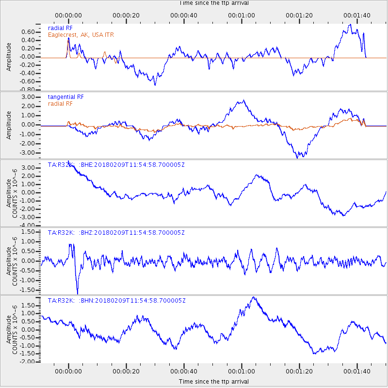
R32K Eaglecrest, AK, USA - Earthquake Result Viewer
*The percent match for this event was below the threshold and hence no stack was calculated.
| Earthquake location: |
Fiji Islands Region |
| Earthquake latitude/longitude: |
-17.9/-178.7 |
| Earthquake time(UTC): |
2018/02/09 (040) 11:43:56 GMT |
| Earthquake Depth: |
545 km |
| Earthquake Magnitude: |
5.9 Mww |
| Earthquake Catalog/Contributor: |
NEIC PDE/us |
|
| Network: |
TA USArray Transportable Network (new EarthScope stations) |
| Station: |
R32K Eaglecrest, AK, USA |
| Lat/Lon: |
58.27 N/134.52 W |
| Elevation: |
386 m |
|
| Distance: |
84.2 deg |
| Az: |
21.713 deg |
| Baz: |
221.814 deg |
| Ray Param: |
$rayparam |
*The percent match for this event was below the threshold and hence was not used in the summary stack. |
|
| Radial Match: |
29.791487 % |
| Radial Bump: |
400 |
| Transverse Match: |
37.859413 % |
| Transverse Bump: |
400 |
| SOD ConfigId: |
13570011 |
| Insert Time: |
2019-04-29 18:41:27.411 +0000 |
| GWidth: |
2.5 |
| Max Bumps: |
400 |
| Tol: |
0.001 |
|
Signal To Noise
| Channel | StoN | STA | LTA |
| TA:R32K: :BHZ:20180209T11:54:58.700005Z | 4.9005938 | 7.107836E-7 | 1.4504029E-7 |
| TA:R32K: :BHN:20180209T11:54:58.700005Z | 0.61585504 | 8.087488E-7 | 1.3132129E-6 |
| TA:R32K: :BHE:20180209T11:54:58.700005Z | 0.79605865 | 1.0353504E-6 | 1.3005956E-6 |
| Arrivals |
| Ps | |
| PpPs | |
| PsPs/PpSs | |


